Suggested Searches

1 min read

Typhoon Chaba

Instruments:
2004-08-26 00:00:00
August 26, 2004

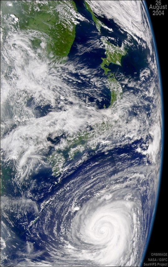
The SeaWiFS sensor aboard the OrbView-2 satellite captured this true-color image of Typhoon Chaba on August 26, 2004 at 3:30 UTC. At the time this image was taken, Chaba was located approximately 1185 km (736 miles) south-southeast of Sasebo, Japan and was moving towards the north-northwest at 15 km/hr (9 mph). Maximum sustained winds were near 213 km/hr (132 mph) with higher gusts to 260 km/hr (161 mph). The Joint Typhoon Warning Center was forecasting Chaba to weaken over the next 72 hours.

References & Resources

Image provided by the SeaWiFS Project, NASA Goddard Space Flight Center, and ORBIMAGE

You may also be interested in:

Stay up-to-date with the latest content from NASA as we explore the universe and discover more about our home planet.

Ragasa Steers Toward China
3 min read

The super typhoon headed for Guangdong province after lashing Taiwan and northern Luzon in the Philippines.

Article
Typhoon Kajiki Lashes Southeast Asia
2 min read

Late summer in the Northwest Pacific Ocean often sees an increase in storminess, which in August 2025 included a typhoon…

Article
The Potomac Island Where History Took Flight
4 min read

Samuel Pierpont Langley conducted the first successful flight of an unpiloted, engine-driven, heavier-than-air craft from a houseboat near Chopawamsic Island…

Article