


This story was updated on August 15, 2023, to include new information about the storm.
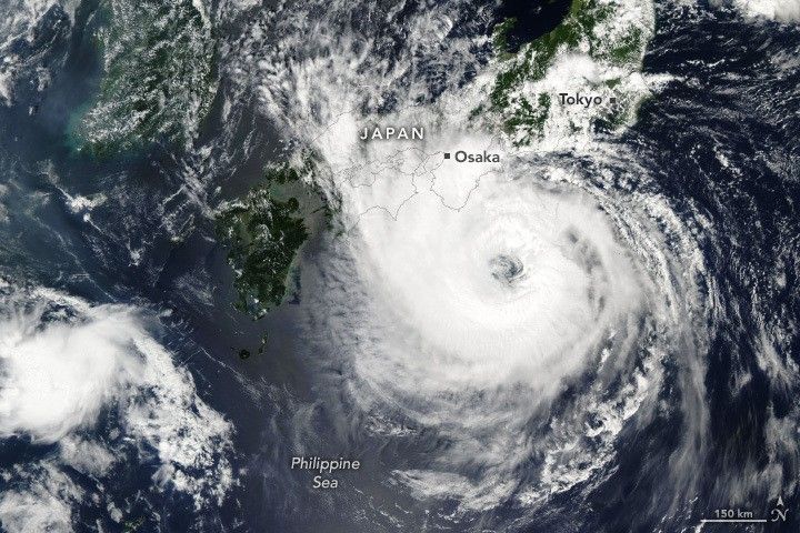
Less than one week after Typhoon Khanun charted a zigzagging course toward southern Japan, the country was preparing for yet another major storm—Typhoon Lan.
The Moderate Resolution Imaging Spectroradiometer (MODIS) on NASA’s Aqua satellite acquired the image at 1:30 p.m. local time (04:30 Universal Time) on August 14, 2023. Around that time, winds were sustained at about 160 kilometers (100 miles) per hour—the equivalent of a category-2 storm on the Saffir-Simpson wind scale.
The storm made landfall over Japan on August 15, 2023, and then moved north toward the cities of Osaka and Kyoto. In addition to heavy rain and high winds, the Japan Meteorological Agency warned of floods, storm surge, and landslides. Airlines and railways cancelled services ahead of the storm.
By the evening of August 15, Lan had weakened to a tropical storm as it neared the Sea of Japan. Rainfall from the slow-moving storm caused rivers to overflow, and strong winds left thousands of homes without power.
References & Resources
- Japan Meteorological Agency (2023, August 15) Warnings and Advisories. Accessed August 14, 2023.
- Joint Typhoon Warning Center (2023, August 14) Typhoon 07W (Lan) Warning #28. Accessed August 14, 2023.
- Kyodo News (2023, August 13) Western, central Japan brace as Typhoon Lan to make landfall Aug. 15. Accessed August 14, 2023.
- Reuters (2023, August 15) Typhoon Lan makes landfall in Japan, thousands urged to seek safety. Accessed August 15, 2023.
- Reuters (2023, August 14) Central Japan braces for Typhoon Lan arrival with air, rail cancellations. Accessed August 14, 2023.
- Weather Underground (2023, August 14) Typhoon Lan. Accessed August 14, 2023.
NASA Earth Observatory image by Wanmei Liang, using MODIS data from NASA EOSDIS LANCE and GIBS/Worldview . Story by Kathryn Hansen .


