


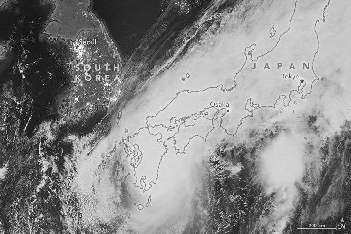
Less than a week after Super Typhoon Meranti barreled down on East Asia, another storm spun into the region. At 17:50 Universal Time on September 19, 2016, (2:50 a.m. local time on September 20), the Visible Infrared Imaging Radiometer Suite (VIIRS) on the Suomi NPP satellite acquired this image of Super Typhoon Malakas over Japan.
This image is from the “day-night band” on VIIRS, which detects green to near-infrared light. A nearly full Moon lit the tops of the clouds. The storm made landfall on Kyushu, with winds gusting up to 65 kilometers (105 miles) per hour across much of the island.
Further Reading
- NASA Earth Observatory (2016, September 16) Study: Typhoons in the Northwestern Pacific are Getting Stronger.
- NASA Earth Observatory (2013, March 5) In a Warming World, Storms May Be Fewer but Stronger.
References & Resources
- Joint Typhoon Warning Center (2016, September 20) TC Warning Graphic. Accessed September 20, 2016.
- Unisys Weather (2016, September) Typhoon-4 MALAKAS. Accessed September 20, 2016.
- Weather Underground News & Blogs (2016, September 20) Malakas Leaves Trail of Damage in Japan. Accessed September 20, 2016.
NASA Earth Observatory image by Jesse Allen, using VIIRS day-night band data from the Suomi National Polar-orbiting Partnership. Suomi NPP is the result of a partnership between NASA, the National Oceanic and Atmospheric Administration, and the Department of Defense. Caption by Adam Voiland.


