


- Quicktime (.mov) format (664 KB)
- MPEG-1 (.mpg) format (980 KB)
As the northern Philippines island of Luzon recovers from its brush withTyphoon Mindulle, the island nation of Taiwan now bears the brunt of thestorm. Mindulle was responsible for 16 fatalities and 17 missing personsin the Philippines mainly from flash floods and is now hitting the eastcoast of Taiwan with 75 mph winds. Mindulle formed into a tropicaldepression from a monsoon gyre back on the 23rd of June 2004 just west ofthe Northern Mariana Islands. Mindulle quickly reached tropical stormstrength but only slowly intensified over the next few days before finallybecoming a minimal typhoon on the 27th in the Philippine Sea. Next came aperiod of rapid development as Mindulle's maximum sustained winds increasedfrom 65 knots (75 mph) to 125 knots (144 mph) within a span of just 30hours, and it's forward speed decreased dramatically as it approached thenorthern Philippines. Up until this point, Mindulle had been moving mainlydue west but now turned north taking it through the Babuyan and Batanislands north of the main island of Luzon. The storm increased its forwardspeed slowly and began to weaken as it passed through the Bashi Channelheaded for Taiwan. Mindulle passed by the Hengchun Peninsula at thesouthern tip of Taiwan on the evening (local time) of the 30th of Junebefore continuing up along the east coast of Taiwan.
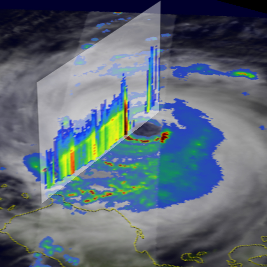
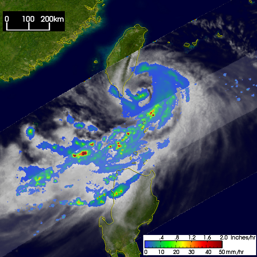
The Tropical Rainfall Measuring Mission (TRMM) satellite has been fulfillingits mission of monitoring rainfall over the global tropics since its launchback in November of 1997. With its passive and active sensors, TRMM is ableto capture unique images of tropical cyclones providing a one of a kindperspective on their structures as seen by this series of images of Mindulle.The first image was taken at 15:39 UTC on 23 June 2004 when Mindulle was stilljust a tropical storm west of the Northern Mariana Islands with maximumsustained winds estimated at 35 knots (40 mph) by the Joint Typhoon WarningCenter. The image shows the horizontal distribution of rain intensity. Rainrates in the center swath are from the TRMM Precipitation Radar (PR), the firstand only precipitation radar in space, and those in the outer swath are fromthe TRMM Microwave Imager (TMI). The rain rates are overlaid on infrared (IR)data from the TRMM Visible Infrared Scanner (VIRS). This image shows thatMindulle is not very organized yet with no evidence of an eye in the rain field.However, some banding is visible in the moderate rain rates (green areas) and asizeable area of intense rain is present (dark red areas). The second image wastaken at 06:01 UTC on the 28th and shows a mature typhoon with a large, well-defined eye surrounded by a definitive eyewall that contains areas of heavy rain(semicircle with dark red areas). At this time Mindulle was a Category 4 stormwith sustained winds estimated at 115 knots (132 mph) as it was approaching thethe the northern Philippines. The next image at this same time shows a verticalcross section through the center of the storm from the PR looking northeast. Itshows the intense rain (black area) in the western eyewall and a broad rainshield of moderate intensity rain (yellow areas) west of the center. Alsoevident is a bright band (horizontal yellow areas) wherein ice particle begin tomelt as they fall through the freezing level. The final image was taken at 4:51UTC on 1 July 2004. It shows a greatly weakened Mindulle hugging the east coastof Taiwan. The eyewall is gone and the center is surrounded by a large swirl ofmostly light rain (blue areas). The heaviest rain rates are part of a largerain band that extends southwest of the center into the northern South China Sea.At this time, the maximum estimated winds were down to 75 knots (86 mph).
TRMM is a joint mission between NASA and the Japanese space agency JAXA.
References & Resources
Images produced by Hal Pierce (SSAI/NASA GSFC) and caption by Steve Lang (SSAI/NASA GSFC), NASA's Tropical Rainfall Measuring Mission.


