


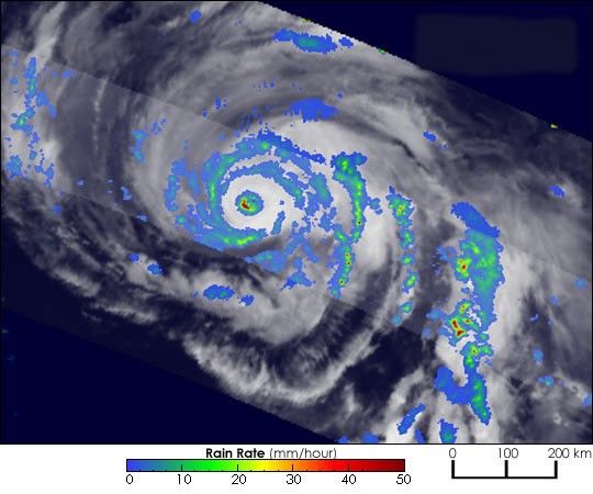
Early on the morning of July 27 (Japanese local time), the Tropical Rainfall Measurement Mission (TRMM) satellite flew directly over the heart of Typhoon Namtheun. The storm, with sustained winds blowing at 105 knots (121 miles per hour), is threatening the southern islands of Japan. Compared with a TRMM overpass obtained the day before, Namtheun has intensified considerably in 24 hours. The current image shows what appears to be a concentric eyewall, or “double-eye” structure, one of the hallmarks of an intense typhoon. The colors in the image indicate rainfall intensity, ranging from blue (low rain rates) to red (high rain rates).
The TRMM satellite, which operates the only weather radar flying in space, is a joint mission between NASA and the Japanese space agency JAXA. Images and data obtained from the TRMM satellite are used by various operational forecast centers around the world, such as the NOAA Tropical Prediction Center and the Pacific Joint Typhoon Warning Center, to obtain precise center location and intensity estimates of tropical cyclones.
References & Resources
Image courtesy of Hal Pierce, NASA GSFC/SSAI.


