


- June 29 (248 KB)
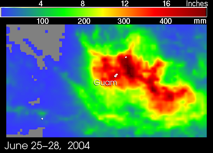
- Rainfall Total (392 KB)
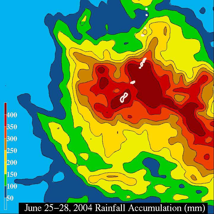
- Rainfall Total - contours (392 KB)
- Quicktime (.mov) format (516 KB)
- MPEG-1 (.mpg) format (660 KB)
Tingting, at the time still a tropical storm, dumped record breaking rainson Guam over the weekend resulting in extensive flooding and mudslides. Theweather service reported that 16 inches of rain fell on Sunday alone (localtime). The tropical depression that would later become Tingting first formedon the 25th of June 2004 several hundred miles east-southeast of the southernMariana Islands. The storm proceeded westward for a short time before turningnorthwest. The system slowly strengthened becoming a tropical storm on the 26thand a minimal typhoon on the 28th as it passed north of Saipan in the centralMarianas. After passing through the island chain, the storm turned northwardand is expected to pass close to Iwo Jima.
The Tropical Rainfall Measuring Mission (TRMM) satellite has been monitoringrainfall over the global tropics since its launch in November of 1997. Armedwith its array of both passive and active sensors, TRMM has been able to imagenumerous tropical cyclones providing a unique perspective on their structures.Such is the case with Tingting as shown by the following images. The firstimage was taken at 4:28 UTC on 28 June 2004 just as Tingting was passingthrough the central Mariana Islands. It shows the horizontal distribution ofrain intensity. Rain rates in the center swath are from the TRMM PrecipitationRadar (PR), the first and only precipitation radar in space, and rain rates inthe outer swath are from the TRMM Microwave Imager (TMI). These rain rates areoverlaid on infrared (IR) data from the TRMM Visible Infrared Scanner (VIRS).This image shows that Tingting has a well-defined center of circulation asevidenced by the spiraling rainbands to the northeast (blue arches). However,the majority of the rainfall is contained in a large rainband well to thesouthwest of the center. This rainband contains areas of heavy (red), moderate(green) and light rain (blue). At the time of this image, Tingting wasclassified as a minimal typhoon by the Joint Typhoon Warning Center with windsestimated at 65 knots (75 mph). The second image was taken at 11:43 UTC on the29th and reveals that the storm had become better organized with a morepronounced eye and a more symmetrical rainfield. However, rain intensitiesaround the eye are rather light (blue areas). As tropical cyclones rely oncondensational heating near their cores to maintain their circulations, theweak rain rates near the storm's center as revealed by TRMM means that Tingtingis not likely to strengthen. Tingting was estimated to have sustained winds of80 knots (92 mph) at the time of this image.
The TRMM-based, near-real time Multi-satellite Precipitation Analysis (MPA) atthe NASA Goddard Space Flight Center provides quantitative rainfall estimatesover the global tropics. The final two images show MPA rainfall totals for theperiod 25-28 June 2004 around Guam as a result of Tingting. The dark red areaover Guam indicates rainfall on the order of 16 to 20 inches which is inexcellent agreement with the reported values on the ground. The final imageshows contoured values in mm.
TRMM is a joint mission between NASA and the Japanese space agency JAXA.
References & Resources
Images produced by Hal Pierce (SSAI/NASA GSFC) and caption by Steve Lang (SSAI/NASA GSFC), NASA's Tropical Rainfall Measuring Mission.


