


One week after dropping flooding rains and killing 14 people in southern Thailand, Tropical Cyclone Vardah was poised for landfall along the east coast of India.
On December 11, 2016, the Moderate Resolution Imaging Spectroradiometer (MODIS) on NASA’s Terra satellite acquired a natural-color image of Vardah (above) as it churned in the Bay of Bengal. Around the same time, the U.S. Joint Typhoon Warning Center reported sustained winds of 75 knots (85 miles or 140 kilometers per hour) and gusts up to 90 knot gusts (105 mph or 165 kmph). Significant wave heights (in the open ocean) approached 24 feet (7.3 meters), and the center of the storm was approximately 640 nautical miles (1030 kilometers) south-southwest of Calcutta.
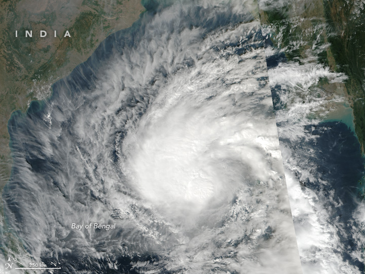
Two days earlier, the Visible Infrared Imaging Radiometer Suite (VIIRS) aboard the Suomi NPP satellite captured an image of the same storm (below) while it was still below hurricane/cyclone force.
Forecasters expect the slow-moving storm to weaken slightly to tropical-storm force before making landfall on December 12 in the Tamil Nadu and Andhra Pradesh states of India. The storm is expected to drop as much as 10 inches (25 centimeters) of rain in some areas, with the potential for flooding. On the other hand, the rain could bring some much-needed relief to drought-ridden areas, such as the parched city of Chennai.
As early as December 8, regional officials put India’s coastal areas on high alert for severe weather impacts. Schools and colleges in the region were canceled in anticipation of the storm.
References & Resources
- Joint Typhoon Warning Center (2016, December 11) Tropical Cyclone Vardah Warning No. 17. Accessed December 11, 2016.
- The Hindu (2016, December 11) Cyclone Vardah: Chennai schools, colleges closed on Monday. Accessed December 11, 2016.
- The Times of India (2016, December 11) Cyclone Vardah likely to bring heavy rain to Chennai. Accessed December 11, 2016.
- The Weather Channel (2016, December 11) Tropical Cyclone Vardah Nearing Landfall in India. Accessed December 11, 2016.
NASA Earth Observatory image (top) by Joshua Stevens and NASA image (bottom) by Jeff Schmaltz, using MODIS data from LANCE/EOSDIS Rapid Response. Caption by Pola Lem and Mike Carlowicz.


