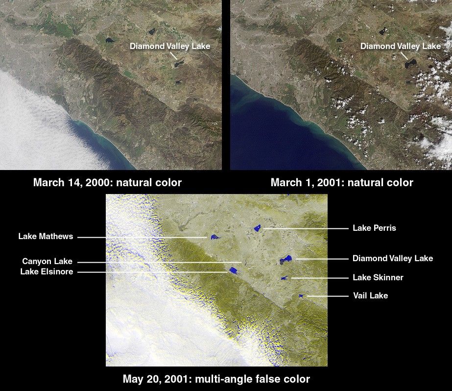
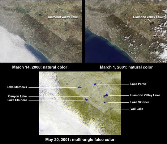
The new Diamond Valley Lake Reservoir near the city of Hemet inRiverside County is billed as the largest earthworks constructionproject in U.S. history. Construction began in 1995 and involved 31million cubic meters of foundation excavation and 84 million cubicmeters of embankment construction. This set of Multi-angle ImagingSpectroradiometer (MISR) images captures themost recent phase in the reservoir's activation. At the upper left is anatural-color view acquired by the instrument's vertical-viewing (nadir)camera on March 14, 2000, shortly after theMetropolitan Water District began filling the reservoir with water fromthe Colorado River and Northern California. Water appears darker thanthe surrounding land. The image at the upper right was acquired nearlyone year later on March 1, 2001, and shows a clearincrease in the reservoir's water content. When full, the lake will holdnearly a trillion liters of water.
According to the Metropolitan Water District, the 7 kilometer x 3kilometer reservoir nearly doubles Southern California's above-groundwater storage capacity. In addition to routine water management, DiamondValley Lake is designed to provide protection against drought and asix-month emergency supply in the event of earthquake damage to a majoraqueduct. In the face of electrical power shortages, it is also expectedto reduce dependence on the pumping of water from northern mountainsduring the high-demand summer months. An unexpected result of siteexcavation was the uncovering of mastodon and mammoth skeletons alongwith bones from extinct species not previously thought to have beenindigenous to the area, such as the giant long-horned bison and NorthAmerican lion. A museum and interpretive center is being built toprotect these finds.
The lower MISR image, from May 20, 2001, is afalse-color view combining data from the instrument's 26-degree forwardview (displayed as blue) with data from the 26-degree backward view(displayed as yellow). This technique enables bodies of water to standout prominently by taking advantage of the strong change in brightnessbetween the two view angles and the contrasting angular signature of thesurrounding land. The blue-yellow separation in the cloud field is dueto geometric parallax resulting from the clouds' elevation above thesurface terrain.
Each image covers an area measuring approximately 125 kilometers x 95kilometers. The northwest to southeast trending linear feature is theElsinore Fault.
References & Resources
Image courtesy NASA/GSFC/LaRC/JPL, MISR Team