During the Southern Hemisphere's summer season, the South Pole bustles with science activity, from cosmic observations to seismic and atmospheric studies. This year, researchers are taking a close look at what lies below.
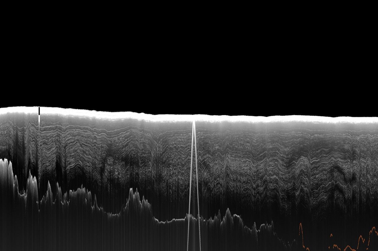
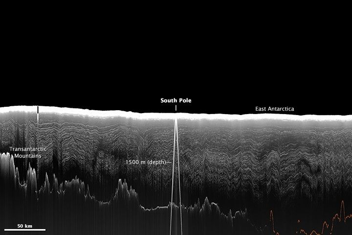
The image above shows a slice through almost 3 kilometers (1.9 miles) of ice spanning a few hundred kilometers on each side of the South Pole. (Note that the horizontal scale differs from the vertical scale.) From this perspective, ice would be flowing into the page, or away from you.
Over many years, snow that fell at the surface has been compressed and transformed into successive layers of ice. The process continues and layers become further compressed under the tremendous weight of the ice sheet. The ice that makes up a single layer is a uniform age and contains information about the composition of the atmosphere at the time that the snow initially fell.
Radar instruments on aircraft can detect these layers by transmitting microwave signals and recording the magnitude of the echoes returned to the instrument. The method works because the strength of the echo varies depending on factors such as density and the amount of impurities in each layer.
In the radar image above, the stratigraphy (layers) appears misshapen in places, possibly caused by drag over rough bedrock “upstream” or from irregular ice flow. Orange lines highlight the part of the bedrock where the data are faint. White lines on either side of the South Pole are reflections from buildings at the surface.
These radar data were collected during an airborne campaign in December 1998 led by the University of Texas Institute for Geophysics (UTIG). For two successive seasons, scientists with the Pensacola-Pole Transect campaign surveyed from the Ross Ice Shelf, southward over the Transantarctic mountains between the Scott and Reedy Glaciers, and over the South Pole. This particular scene was collected over the course of two days.
According to Don Blankenship, whose UTIG team collected the data and later prepared this image, "this is one of the few and possibly the most recent image of this particular transect through the South Pole." There has not yet been a scientific need to collect newer imagery across a such a large swath of the region.
The view recently proved useful for scientists choosing a site for the drilling and recovery of a new ice core. Scientists began drilling in early December 2014, and when completed in 2016 the core will be the deepest yet recovered from near the South Pole. Scientists aim to drill down 1,500 meters (4,900 feet) to where the ice is about 40,000 years old. Analysis of the layers will provide a detailed history of the climate and environment in a unique area of the continent where moist air from the west meets cold, dry air from the east.
According to NASA cryospheric scientist Tom Neumann: "The low temperature and relatively high accumulation rate here could give us an excellent record of the chemistry of the polar atmosphere over the last 40,000 years."
References & Resources
- Casey, K.A. et al., (2014) The 1500 m South Pole ice core: recovering a 40 ka environmental record. Annals of Glaciology 55 (68), 137-146.
- South Pole Ice Core (2014) Overview. Accessed December 22, 2014.
- National Snow & Ice Data Center (2014) What is a glacier? Accessed December 22, 2014.
- University of Copenhagen Centre for Ice and Climate (2014) Ice core impurities Accessed December 22, 2014.
Images courtesy of Don Blankenship and Marie Cavitte, University of Texas Institute for Geophysics (UTIG), based on work funded by the National Science Foundation. Caption by Kathryn Hansen.