


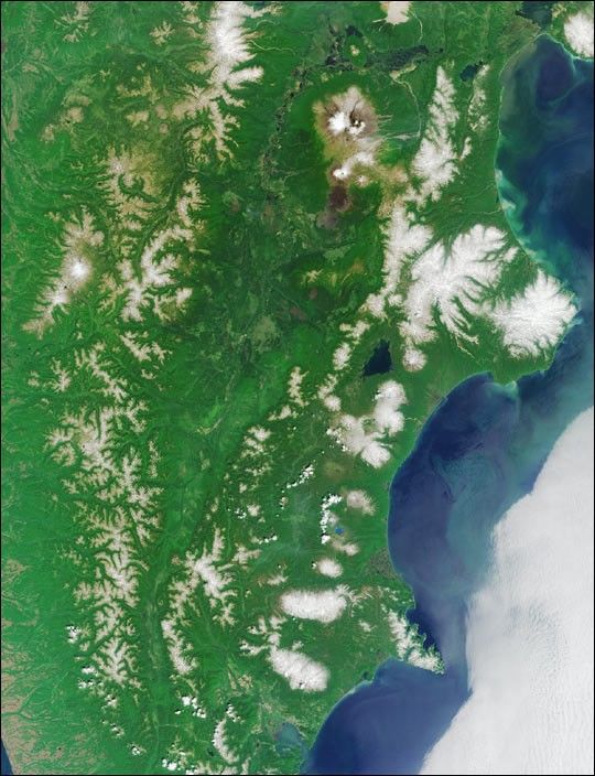
Here’s another chance to play geographical detective! This natural-colorimage was acquired by the Multi-angle Imaging SpectroRadiometer (MISR)in July 2003, and represents an area of about 355 kilometers x 463kilometers. Most of the landmass pictured in this image falls within anamed geographic region. This region is defined by its politicalboundaries within a larger country, and may be a state, a province, adepartment, or similar entity. These 6 questions refer to thisgeographic region. You may use any reference materials you like toanswer them.
1. Averaged over the entire geographic area of the region, which is larger?
nbsp; (A) The average number of people per square kilometer.
nbsp; (B) The average number of volcanoes per 1000 square kilometers.
2. Which is closer to the image area?
nbsp; (A) The nearest point along the path of annularity of the first solareclipse of 2003.
nbsp; (B) The location where a cargo ship spilled tens of thousands of bathtubtoys during rough seas in the early 1990s.
3. Which is smaller?
nbsp; (A) The population of the region at the beginning of the 18th century.
nbsp; (B) The population of the region at the beginning of the 20th century.
4. Which occurred earlier?
nbsp; (A) Completion of a monument commemorating the seafarer who founded whatis now the regional capital city.
nbsp; (B) The attack on the port of the city and defense of the port by a44-gun frigate.
5. Which is smaller?
nbsp; (A) The number of masts of the ship upon which the aforementionedseafarer sailed during the last voyage of his or her lifetime.
nbsp; (B) The number of animals first identified and named after thenaturalist who sailed with the seafarer.
6. Within the region, which is further north?
nbsp; (A) The main military base.
nbsp; (B) The most important lake-environment spawning ground for anadromous fish.
E-mail your answers, name (initials are acceptable if you prefer), andyour hometown by Tuesday, October 7 to suggestions@mail-misr.jpl.nasa.gov.Answers will be published on the MISR web site. The namesand home towns of respondents who answer all questions correctly by thedeadline will also be published in the order responses were received.The first 3 people on this list who are not affiliated with NASA, JPL,or MISR and who have not previously won a prize will be sent a print ofthe image.
A new "Where on Earth...?" mystery appears approximately once every two months. New featured images arereleased on Wednesdays at noon Pacific time on the MISR home page,http://www-misr.jpl.nasa.gov and on the AtmosphericSciences Data Center home page, http://eosweb.larc.nasa.gov/, thoughusually with a several-hour delay.
References & Resources
Image courtesy NASA/GSFC/LaRC/JPL, MISR Team. Text by Clare Averill MISR Team, Geographic Interpretation and Science Outreach, c/o Raytheon, Australia.


