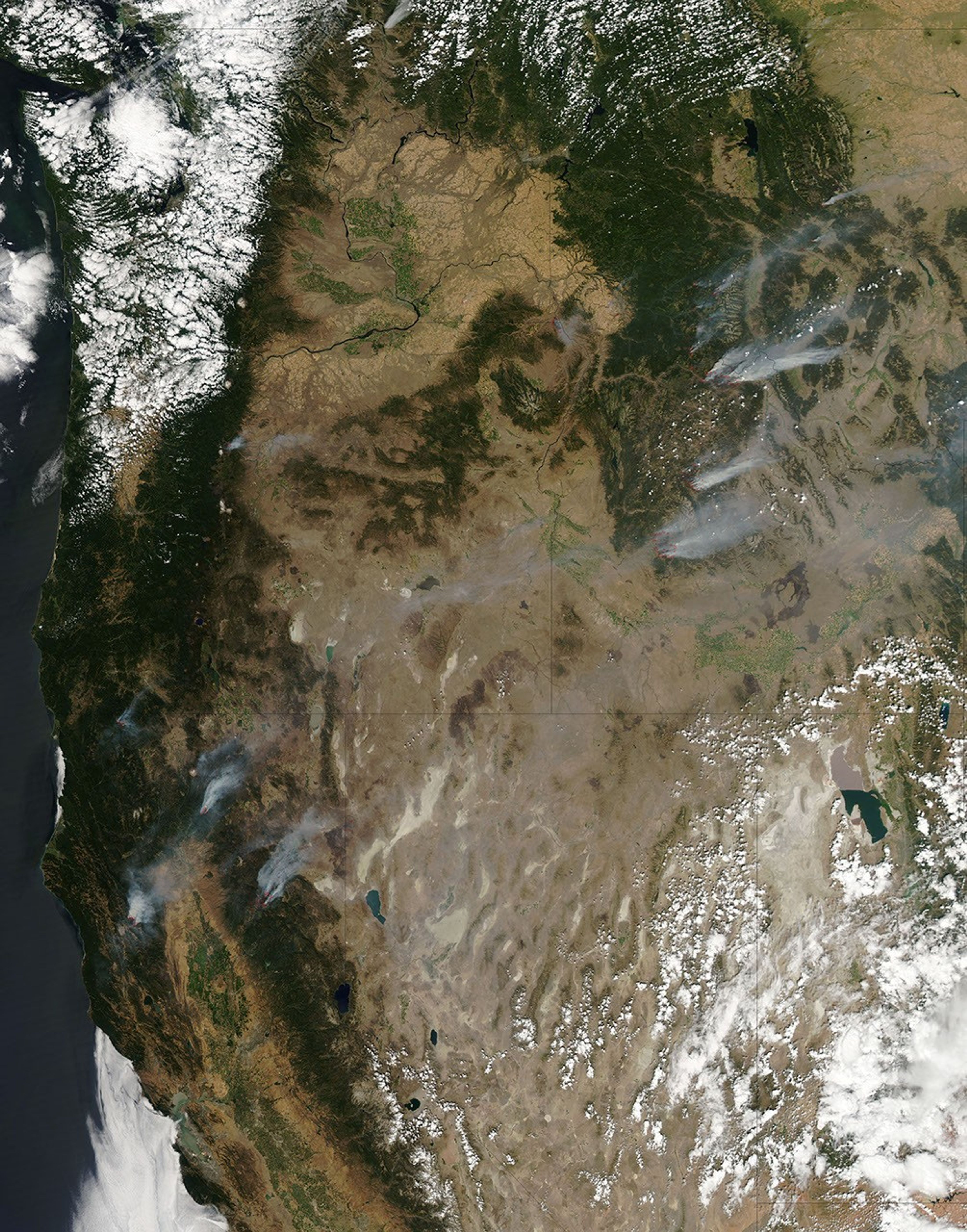
Hot, dry, and gusty conditions continued to exacerbate wildfires throughout the western United States on August 24, 2012. In northern California, one of the areas most severely affected, several fires burned. Most blazed in remote areas, but the Ponderosa fire had destroyed several dozen homes and threatened hundreds of others.
This natural-color satellite image shows smoke from the fires streaming northeast. It was acquired by the Moderate Resolution Imaging Spectroradiometer (MODIS) aboard the Aqua satellite on August 23, 2012. Red outlines indicate hot spots where MODIS detected unusually warm surface temperatures associated with fire activity.
By August 24, the Bagley fire (5 percent contained) had burned 11,083 acres (4,485 hectares), the Chips fire (55 percent contained) had burned 63,100 acres, the Fort Complex fire (37 percent contained) had burned 6,683 acres, the North Pass fire (10 percent contained) had burned 17,820 acres, and the Ponderosa fire (68 percent contained) had burned 28,089 acres.
The 2012 wildfire season nearly ranks first for the number of acres burned at this point in the year. According to the National Interagency Fire Center, 7.15 million acres have burned as of August 24, 2012. In 2006, 7.17 million acres had burned at this point in the season.
This season may break a record for the total number of acres burned in a year. In 2006, the current record holder, 9.87 million acres burned.
Further Reading
- NPR. (2012, Aug. 20). Special Series: Wildfires. Accessed August 24, 2012.
- Find the Data. (2012, Aug. 20). Wildfires Acres Burned. Accessed August 24, 2012.
References & Resources
- Inciweb. (2012, August 24). Inciweb: California Fires. Accessed August 24, 2012.
- CalFire. (2012, August 24). Ponderosa Fire. Accessed August 24, 2012.
- National Interagency Fire Center. (2012, August 24). Year-to-Date Statistics. Accessed August 24, 2012.
- National Interagency Fire Center. (2012, August 24). Total Wildland Fires and Acres (1960-2011). Accessed August 24, 2012.
NASA image courtesy Jeff Schmaltz, LANCE MODIS Rapid Response. Caption by Adam Voiland.