


Introduction
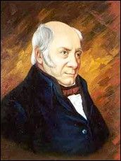
One evening in southern England more than 200 years ago, three friends with a common interest in rocks and fossils met for dinner and discussed the fledgling field of geology. Two of the men, Joseph Townsend and Benjamin Richardson, were clergymen and fossil collectors who looked to the natural world for tangible evidence God’s handiwork. The third was a young surveyor and canal engineer named William Smith, who possessed an extensive understanding of England’s rock layers, or strata.
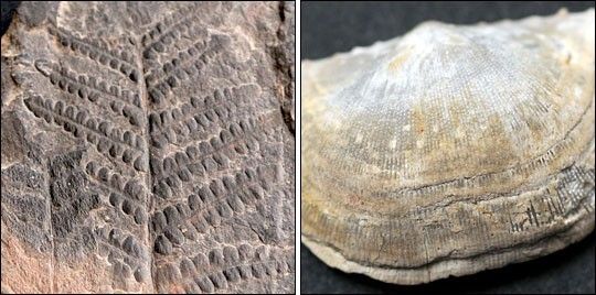
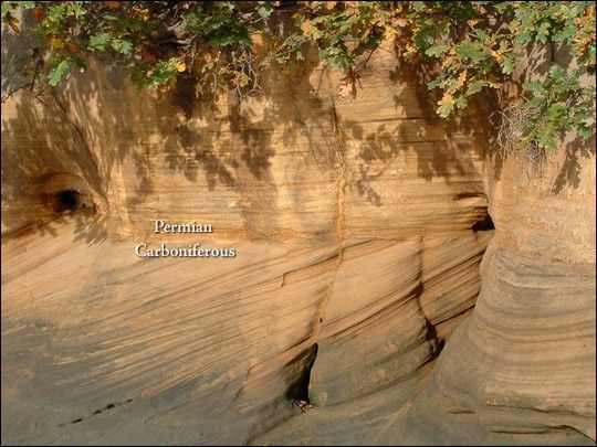
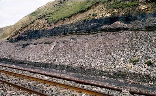
After dinner, the men made a chart of the rock strata in the vicinity of Bath, identifying strata by color, hardness, and the fossils they held. In all, they named 23 layers, employing colorful names like Fuller’s Earth, Lias Blue, and Ditto White. Among these layers, the men noted something odd. Between strata they called Millstone and Pennant Stone was a dramatic change in the kinds of fossils found in the rocks. In the Millstone layer, plant fossils dominated. In the Pennant Stone layer, marine mollusk shells dominated.
Today, geologists recognize this fossil turnover as the boundary between the Carboniferous Period (360 to 300 million years ago), when abundant swamps laid the foundation for many of today’s coal beds, and the Permian Period (300 to 250 million years ago), when Earth’s landmasses coalesced into a single continent. In 1799, however, when Smith and his friends noted the fossil shift, they didn’t grasp the hundreds of millions of years of changing landscapes that geologists recognize today.
For Smith, the finding provided more evidence for his idea that rock layers across England occurred in a predictable pattern, and that wherever they occurred, they could be identified and connected to distant rock outcrops by the unique collections of fossils they held. He called this idea the principle of faunal succession, or fossil succession.
In the short term, the principle of faunal succession allowed Smith to place rock formations in the proper order throughout England, to identify lucrative coal seams for a fuel-hungry nation, and to publish a geologic map of England and Wales—the most detailed, accurate map then produced for such a large area. In the long run, it helped succeeding generations of scientists uncover the history of life on Earth.
Changing Pictures of the Past
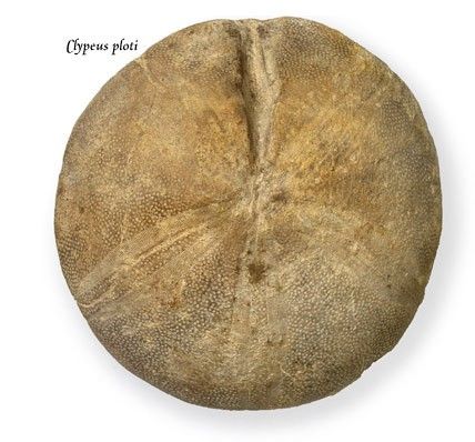
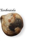
William Smith was born on March 23, 1769. When he was eight, his father died, and his mother sent him to live on an uncle’s farm. Smith’s own nephew would later recount how the boy’s new guardian “was little pleased with his nephew’s love of collecting ‘pundibs’ and ‘poundstones’” that littered the farm. The pundibs, which made excellent marbles for Smith and his boyhood friends, were really tiny, ancient brachiopods—marine invertebrates with a superficial resemblance to clams. The handy pound weights sometimes used to balance butter scales were actually fossil sea urchins—harder to recognize without their spiky armor.
As a little boy, Smith likely didn’t grasp what these objects were, but some keen thinkers did. In the centuries before his birth, natural historians had debated what fossils might be—remains of once-living organisms or products of the planet’s alleged ability to grow plant and animal look-alikes in rock. By Smith’s time, geologists widely accepted that fossils were the remains of living things, the same conclusion reached by the seventeenth-century scholar and Danish anatomist Nicolaus Steno.
Steno had also proposed several principles about rock formation that, by Smith’s time, most geologists embraced: older rocks generally lay below younger ones and layers of sedimentary rocks were originally laid down horizontally, even if geologic upheavals tilted them afterwards. By the early nineteenth century, respected geologists throughout Europe tacitly agreed—contrary to a literal interpretation of the Bible—that our planet possessed an unimaginably long pre-human history.
Discovering Faunal Succession
When Smith was little, fossil brachiopods may have been nothing more than marbles, and he might have forgotten fossils altogether had he lived at a different time. But he grew up when the Industrial Revolution focused England’s attention on the compressed, hardened remains of ancient swamps—coal. Smith wasn’t wealthy and his opportunities for formal education were limited, but he was bright, and he found work as a surveyor when he was just 18. His work required him to visit numerous coal mines, and his trips down the mineshafts showed him that rock layers occurred in predictable sequences. He started to suspect that these sequences extended across England.
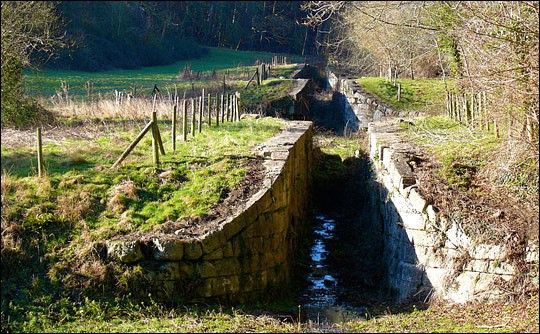
Smith’s work gave him an opportunity to test his hypothesis. To take advantage of fossil fuels, England’s industrialists didn’t just have to dig up coal, they had to transport it efficiently. Before settling on train transport, England experimented with canals. As a surveyor for many of these canals, Smith traveled some 10,000 miles per year, mapping strata as he went. Digging a canal meant slicing through rock layers across miles of landscape, and the cross-sectional views of strata allowed Smith to confirm the order of rock layers across wide distances. But not all of Smith’s research was straightforward. Sometimes it was perplexing.
He was confident that rock strata—now tilted, or dipped—had first been deposited in horizontal layers, and to walk past them was to move forward or backward in the rock sequence. But he couldn’t know the details of the processes that had fashioned England’s landscapes. When he found a sandy deposit in one place and a similar sandy deposit elsewhere, he had to ask whether they were part of the same rock formation laid down at the same time. Smith needed a way to tell layers apart, no matter where in England they were located. As he accumulated observations of strata and fossils in mines and canals, he found the key to telling the layers apart: their fossils were different.
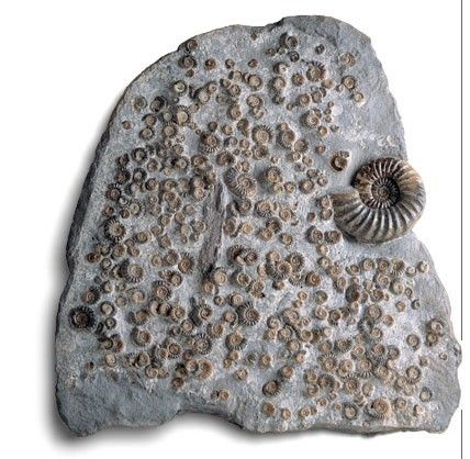
Smith noticed that two beds of rock might contain several identical fossil species, but one or two species would vary. These subtle differences between fossil groups, or assemblages, enabled Smith to differentiate rock strata that appeared otherwise identical. In Strata Identified by Organized Fossils, published from 1816 to 1819, he recalled:
"Fossil Shells had long been known amongst the curious, collected with care, and preserved in their cabinets, along with other rarities of nature, without any apparent use. That to which I have applied them is new, and my attention was first drawn to them, by a previous discovery of regularity in the direction and dip of the various Strata in the hills around Bath; for it was the nice distinction which those similar rocks required, which led me to the discovery of organic remains peculiar to each Stratum."
This was the finding that became known as Smith’s Principle of Faunal Succession. Today it appears in geology textbooks the world over.
Successes, Failures, and Final Years
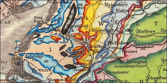
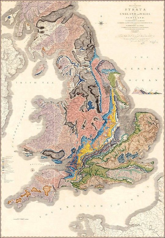
Besides developing the Principle of Faunal Succession, Smith also undertook the most ambitious geologic map-making project of his time: a geologic map of all of England. Instead of mapping just the surface, he had to map what lay below it, translating three dimensions into two. Inspired by an agricultural map that used color-coding to convey an added layer of information, he published A Map of Five Miles round the City of Bath in 1799, one of the world’s first geologic maps.
After publishing his Bath map, he began to think on a grander scale. Although friends encouraged him to hurry and publish before anyone else, assorted setbacks delayed the project for years. Worse, Smith was a procrastinator. He eventually triumphed over the slower part of his nature, and on August 1, 1815, he published A Delineation of the Strata of England and Wales with a part of Scotland. On a scale of 5 miles per inch, the map measured 6 feet by 8 feet 6 inches. Like the agricultural map he had seen years before, this map was colored, with color gradations indicating where one rock formation gave way to the next. Earlier geologists had mapped rock formations and even used fossils to identify rocks, but Smith’s was the first map to depict so many rock formations over such a large area.
Smith produced this impressive work on his own, often using his own money, perhaps to his later regret. Although he had enjoyed steady employment in his early surveying days, he later freelanced, earning an unsteady income. He also began acquiring pricey properties: a country estate, office space in the fashionable resort town of Bath, a four-storey home in London. By the time his map was finally published, he was selling his treasured fossil collection to the British Museum to raise cash. Painful as the fossil sale was, it only postponed the inevitable. On June 11, 1819, Smith began an 11-week sentence in King's Bench, one of London's notorious debtors’ prisons.
His own extravagance probably wasn’t the only explanation for Smith’s financial problems. His stint in debtors’ prison might have been avoided if his map had sold better, and it likely would have, had it not been eclipsed by a competitor. George Bellas Greenough, gentleman geologist and president of the Geological Society of London, was the driving force behind the map that challenged Smith’s. Thanks to the unwitting assistance of an associate of Smith’s, Greenough obtained access to Smith’s manuscripts, which he used with little acknowledgement. Backed by the prestige and resources of the Geological Society, Greenough improved slightly upon Smith’s work, and because his map was priced lower, it undercut Smith’s sales.
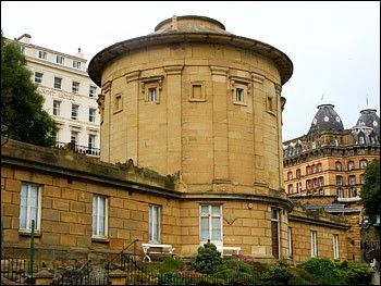
After his release from debtors’ prison, Smith took a series of odd jobs throughout northern England, teaching courses for local philosophical societies in between. In Scarborough, he helped establish the city museum, including designing its rotunda. His design allowed fossils to be displayed along the outer walls in the same order in which they are naturally found in strata, giving visitors ascending the museum’s spiral staircase a visual guide to the history of life on Earth.
After years of moving from job to job, Smith found steady employment and a fairly permanent home as a land steward on a large estate. Around that time, he began to receive overdue accolades for his work. In 1831, the Geological Society, which had refused him membership earlier, awarded him the Wollaston Medal, its highest honor. He received an honorary doctorate of letters from Trinity College, Dublin. And perhaps most practical, he received a lifetime pension from King William IV.
William Smith died on August 28, 1839, after a brief illness. His final years had been happy ones in which he enjoyed the financial stability and professional recognition he had long awaited. In March 2007, a restored copy of his geologic map of England was unveiled—next to a map of Greenough’s—in the East staircase of the Burlington House, current home to the Geological Society of London.
Faunal Succession’s Legacy
Although it might seem surprising, Smith’s principle of faunal succession didn’t provide an immediate understanding of the history of life on Earth, perhaps because his intentions were more practical than scientific: to accurately order rock layers and to help coal prospectors identify the best places to dig. A generation later, John Phillips, Smith’s nephew and biographer, went on to name the major eras in today’s geologic timescale: Paleozoic (ancient life), Mesozoic (middle life), and Cenozoic (new life). These periods were based on the fossil record, much of it documented by Smith.
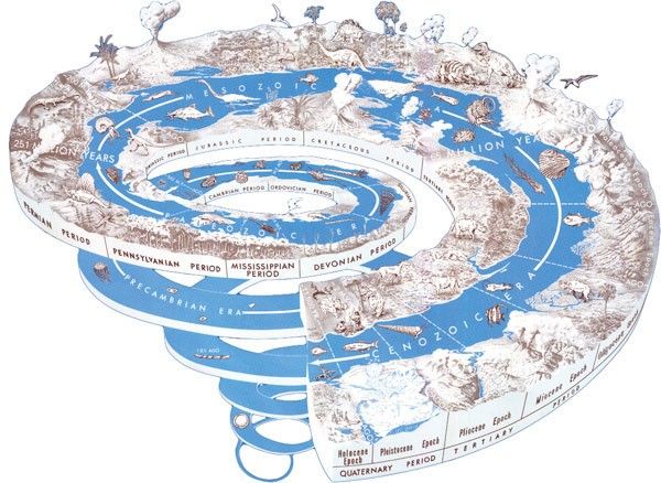
“The Geologic Timescale is the Principle of Fossil Succession at its best,” says Jaelyn Eberle. Curator of vertebrate paleontology and assistant professor of geology at the University of Colorado-Boulder, Eberle teaches her students about how the divisions within the geologic timescale are all based on fossil turnovers in the rock record—periods when species of plants and animals went extinct or originated. Before radiometric dating enabled geologists to apply absolute dates to rocks, she explains, dating rock layers relative to each other based on their fossils was the best method available. And because not every rock can be dated radiometrically, relative dating with fossils continues—and in fact, it predominates—today. “All of us are using the Principle of Faunal Succession,” she says.
Fossils don’t just allow scientists to date rock layers, but also to uncover past climates, some of which differ dramatically from today’s. One of the best examples is the Eocene Epoch, roughly 55 to 34 million years ago. Although the continents were mostly in the same position then that they are today, Eberle has dug Eocene fossils in the Arctic and found a surprising collection of warm-weather fauna. “We’ve found fossils of alligators, turtles, tapirs, even primates,” she says. Fossil plants also left evidence of a warmer climate. Eocene coal seams—compressed, old swamps—are abundant in the Arctic, as are ancient tree trunks and leaf impressions.
Fossil succession has helped scientists to understand that not only has Earth’s climate changed throughout history, the ground itself has shifted across the planet’s surface. Among the evidence that Alfred Wegener provided for his theory of continental drift was that rock strata laid down at the same time in Africa and South America contained identical fossils—even though today they are on opposite sides of the Atlantic.
The influence of faunal succession would also eventually affect biology. Although Charles Darwin and Alfred Russel Wallace would not propose the theory of natural selection until after Smith’s death, Smith’s work enabled geologists and biologists of subsequent generations to think in terms of long expanses of time—a necessary ingredient for Darwinian evolution to occur.
Unlike some early nineteenth-century naturalists, Smith didn’t use fossils to reconstruct past environments or a detailed history of Earth. Yet his principle of fossil succession became the underpinning of much of our understanding about how dramatically Earth’s climate, continents, and life itself have changed over time.
References
Adams, F.D. (1954). The Birth and Development of the Geological Sciences. New York: Dover Publications, Inc. ISBN: 0-486-20005-1.
Morrell, J. (2005). John Phillips and the Business of Victorian Science. London: Ashgate Publishing.
Phillips, J. (1844). Memoirs of William Smith, LL.D., Author of the “Map of the Strata of England and Wales.” London: John Murray, Albemarle Street.
Rudwick, M.J.S. (1985). The Great Devonian Controversy: The Shaping of Scientific Knowledge among Gentlemanly Specialists. Chicago: University of Chicago Press.
Rudwick, M.J.S. (1992). Scenes from Deep Time: Early Pictorial Representations of the Prehistoric World. Chicago: University of Chicago Press.
Rudwick, M.J.S. (2005). Bursting the Limits of Time: The Reconstruction of Geohistory in the Age of Revolution. Chicago: University of Chicago Press.
Smith, W. (1816-1819). Strata identified by organized fossils, containing prints on coloured paper of the most characteristic specimens in each stratum. London: W. Arding.
Winchester, S. (2001). The Map that Changed the World: William Smith and the Birth of Modern Geology. New York: Harper Collins.
Geological Society of London. (2007, March). Maps restored! Accessed March 6, 2008.
Links
- University of Colorado-Boulder, Department of Geological Sciences. Accessed March 20, 2008.
- University of New Hampshire, Department of Earth Sciences. Accessed April 9, 2008.
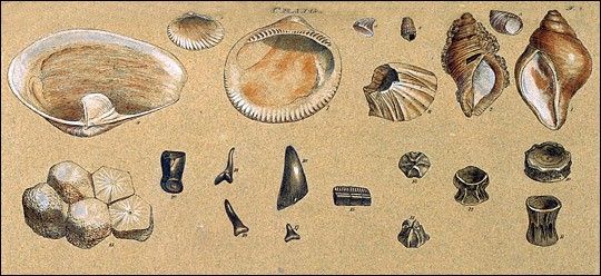
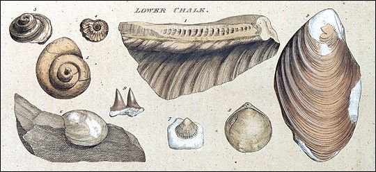
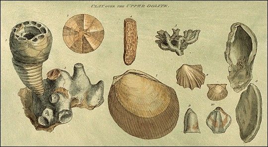
Order of the STRATA and their imbedded ORGANIC REMAINS, in the vicinity of BATH; examined and proved prior to 1799.
| Strata. | Thickness. | Springs. | Fossils, Petrifactions, &c. &c. | Descriptive Characters and Situations. |
|---|---|---|---|---|
| 1. Chalk | 300 | Intermitting on the Downs | Echinites, pyrites, mytilites, dentalia, funnel-shaped corals and madrepores, nautilites, strombites, cochliæ, ostreæ, serpulæ | Strata of Silex, imbedded. |
| 2. Sand | 70 | The fertile vales intersecting Salisbury Plain and the Downs. | ||
| 3. Clay | 30 | Between the Black Dog and Berkeley. | ||
| 4. Sand and Stone | 30 | Imbedded is a thin stratum of calcareous grit. The stones flat, smooth, and rounded at the edges. | ||
| 5. Clay | 15 | Hinton, Norton, Woolverton, Bradford Leigh. | ||
| 6. Forest Marble | 10 | A mass of anomiæ and high-waved cockles, with calcareous cement | The cover of the upper bed of freestone, or oolite. | |
| 7. Freestone | 60 | Scarcely any fossils besides the coral | Oolite, resting on a thin bed of coral.—Prior Park, Southstoke, Twinny, Winsley, Farley Castle, Westwood, Berfield, Conkwell, Monkton Farley, Coldhorn, Marshfield, Coldashton. | |
| 8. Blue Clay | 6 | Above Bath | ||
| 9. Yellow Clay | 8 | |||
| 10. Fuller’s Earth | 6 | Visible at a distance, by the slips on the declivities of the hills round Bath. | ||
| 11. Bastard ditto, and Sundries | 80 | Striated cardia, mytilites, anomiæ, pundibs and duck-muscles | ||
| 12. Freestone | 30 | Top-covering anomiæ with calcareous cement, strombites, ammonites, nautilites, cochliæ hippocephaloides, fibrous shell resembling amianth, cardia, prickly cockle, mytilites, lower stratum of coral, large scollop, nidus of the muscle with its cables | Lincombe, Devonshire Buildings, Englishcombe, Englishbatch, Wilmerton, Dunkerton, Coomhay, Monkton Coombe, Wellow, Mitford, Stoke, Freshford, Claverton, Bathford, Batheaston and Hampton, Charlcombe, Swanswick, Tadwick, Langridge. | |
| 13. Sand | 30 | Ammonites, belemnites | Sand burs. | |
| 14. Marl Blue | 40 | Round Bath. | Pectenites, belemnites, gryphites, high-waved cockles | Ochre balls.—Mineral springs of Lincombe, Middle Hall, Cheltenham. |
| 15. Lias Blue | 25 | Same as the marl with nautilites, ammonites, dentalia, and fragments of the enchrini | The fertile marl lands of Somersetshire. Twerton, Newton, Preston, Clutton, Stanton Prior, Timsbury, Paulton, Marksbury, Farmborough, Corston, Hunstreet, Burnet, Keynsham, Whitchurch, Salford, Kelston, Weston, Pucklechurch, Queencharlton, Norton-malreward, Knowle, Charlton, Kilmersdon, Babington. | |
| 16. Ditto White | 15 | |||
| 17. Marl Stone, Indigo and Black Marl | 15 | Pyrites and ochre | A rich manure | |
| 18. Red-ground | 180 | No fossil known | Pits of riddle. Beneath this bed no fossil, shells, or animal remains are found : above it no vegetable impressions. The waters of this stratum petrify in the trunks which convey it, so as to fill them, in about fifteen years, with red watricle, which takes a fine polish.—Highlittleton. | |
| 19. Millstone. | Impressions of unknown plants resembling equisetum. | |||
| 20. Pennant Street (sic) | ||||
| 21. Grays | Fragments of coal and iron nodules.—Hanham, Brislington, Mangotsfield, Downend, Winterbourn, Forest of Dean, Pensford, Publow, Chelwood, Cumptondando, Hallatrow near Stratford-on-Avon, Stonebench on the Severn, four miles from Gloucester. | |||
| 22. Cliff | Impressions of ferns, olive, stellate plants, threnax-parvi-flora, or dwarf fan-palm of Jamaica | Stourbridge, or fire-clay | ||
| 23. Coal |
NASA Earth Observatory story by Michon Scott. Design by Robert Simmon.


