


browse image of orbit 15741
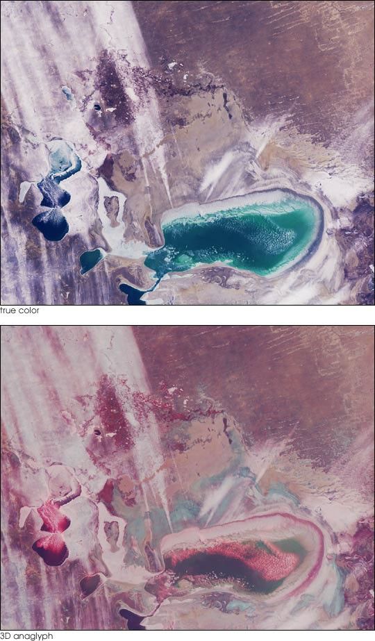
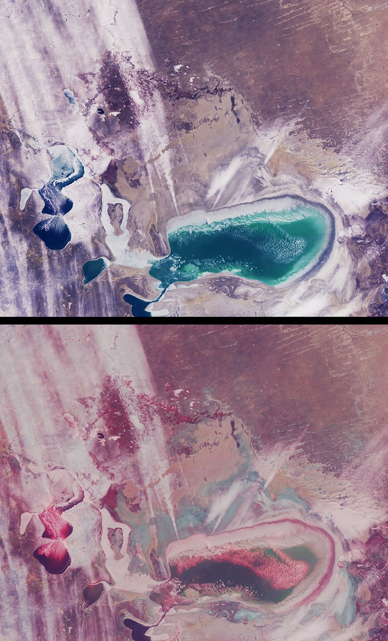
As recently as the 1960’s the Aral Sea of Kazakhstan and Uzbekistan wasthe fourth-largest inland sea in the world. Since then, its water volumehas dropped by about 80% due to extensive irrigation systems developedduring the Soviet era to produce cotton and other crops. What was once asingle body of water has now separated into several smaller seas. Sincethe separation of the Little Aral from the Large Aral in 1987, theshores of what had once been an island in the middle of the Large Aral(Vozrozhdeniya Island) have expanded to form a land bridge that almostcompletely separates the eastern and western parts of the Large Aral.These views from the Multi-angle Imaging SpectroRadiometer (MISR)portray the Little Aral and the eastern Large Aral at the onset ofwinter, on December 3, 2002.
A natural-color view from MISR’s nadir camera is shown at top, while thebottom panel is a 3D stereo anaglyph in which red-band data from the60-degree forward-viewing camera is combined with green and blue-banddata from the nadir (vertical-viewing) camera. To facilitate stereoviewing, the images have been rotated so that north is toward the leftand east is toward the top. Viewing the anaglyph in 3D requires the useof red-blue glasses, with the red filter placed over your left eye.Information on ordering glasses can be found athttp://photojournal.jpl.nasa.gov/Help/VendorList.html#Glasses. TheLittle Aral Sea is located near the left-hand edge of these images, andthe eastern portion of the Large Aral is below image center.
Of the two major rivers that once fed the Aral Sea, the freshwatercontribution from the Amu Darya River is now negligible. The Syr DaryaRiver now only feeds the Little Aral. Depletion of the Aral Sea has ledto soil and water salination and agrochemical contamination. Theretreating shoreline leaves the surface encrusted with salt and withagrochemicals brought in by the rivers. As the Sea’s moderating climaticinfluence has diminished, temperature variations in the region havealtered, resulting in colder winters and hotter, drier summers. Whenstrong westerly winds occur, large quantities of saline dust (andagrochemical toxins) can travel several hundred kilometers.
In these images, several groups of low cumulus clouds are clustered overopen bodies of water and are identifiable in the stereo view by theirheight above the surface. A number of large white streaks extendeastward toward the Kyzylkum desert. Although their altitude cannot beascertained from the nadir image, the stereo anaglyph shows that theyare close to, or at, the surface. Several of these features originatefrom the eastern edge of the Large Aral, and may be associated withwindblown snow and/or salt particles carried aloft.
The Multi-angle Imaging SpectroRadiometer observes the daylit Earthcontinuously and every 9 days views the entire globe between 82 degreesnorth and 82 degrees south latitude. The MISR Browse Image Viewer provides access tolow-resolution true-color versions of these images. These data products were generatedfrom a portion of the imagery acquired during Terra orbit 15741. Thepanels cover an area of about 370 kilometers x 300 kilometers.
References & Resources
Image courtesy NASA/GSFC/LaRC/JPL, MISR Team.


