


before
after

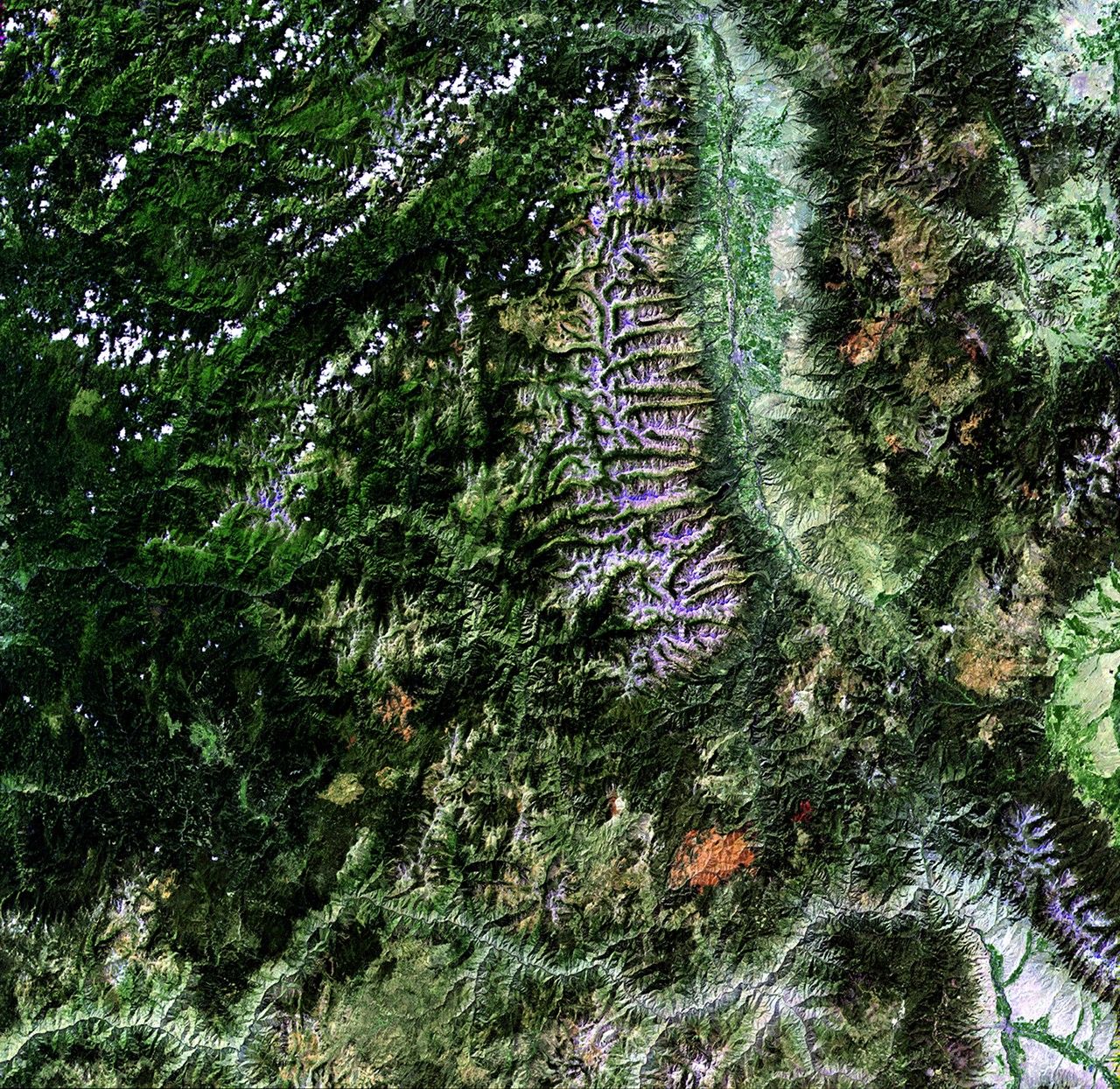
The Mustang Complex Fire, sparked by a lightning strike on July 30, 2012, has consumed more than 330,000 acres of the Salmon-Challis National Forest in northeastern Idaho. By the end of September, the U.S. Forest Service announced that the fire had been "significantly moderated" and that rehabilitation was beginning. Still, high winds and extreme drought continued to hamper the efforts of those working to extinguish the flames, and many homes were still threatened. The July image shows the area shortly before the fire began. The September image shows the forest when the fire was active. Images taken by the Enhanced Thematic Mapper Plus sensor onboard Landsat 7. Source: U.S. Geological Survey (USGS) Landsat Missions Gallery, "Mustang Complex Fire," U.S. Department of the Interior / USGS and NASA.

The Mustang Complex Fire, sparked by a lightning strike on July 30, 2012, has consumed more than 330,000 acres of the Salmon-Challis National Forest in northeastern Idaho. By the end of September, the U.S. Forest Service announced that the fire had been "significantly moderated" and that rehabilitation was beginning. Still, high winds and extreme drought continued to hamper the efforts of those working to extinguish the flames, and many homes were still threatened. The July image shows the area shortly before the fire began. The September image shows the forest when the fire was active. Images taken by the Enhanced Thematic Mapper Plus sensor onboard Landsat 7. Source: U.S. Geological Survey (USGS) Landsat Missions Gallery, "Mustang Complex Fire," U.S. Department of the Interior / USGS and NASA.
The Mustang Complex Fire, sparked by a lightning strike on July 30, 2012, has consumed more than 330,000 acres of the Salmon-Challis National Forest in northeastern Idaho. By the end of September, the U.S. Forest Service announced that the fire had been "significantly moderated" and that rehabilitation was beginning. Still, high winds and extreme drought continued to hamper the efforts of those working to extinguish the flames, and many homes were still threatened. The July image shows the area shortly before the fire began. The September image shows the forest when the fire was active. Images taken by the Enhanced Thematic Mapper Plus sensor onboard Landsat 7. Source: U.S. Geological Survey (USGS) Landsat Missions Gallery, "Mustang Complex Fire," U.S. Department of the Interior / USGS and NASA.
The Mustang Complex Fire, sparked by a lightning strike on July 30, 2012, has consumed more than 330,000 acres of the Salmon-Challis National Forest in northeastern Idaho. By the end of September, the U.S. Forest Service announced that the fire had been "significantly moderated" and that rehabilitation was beginning. Still, high winds and extreme drought continued to hamper the efforts of those working to extinguish the flames, and many homes were still threatened. The July image shows the area shortly before the fire began. The September image shows the forest when the fire was active. Images taken by the Enhanced Thematic Mapper Plus sensor onboard Landsat 7. Source: U.S. Geological Survey (USGS) Landsat Missions Gallery, "Mustang Complex Fire," U.S. Department of the Interior / USGS and NASA.
before
after
Before and After
Mustang Complex fire, Idaho
July 21, 2012 - September 7, 2012
The Mustang Complex Fire, sparked by a lightning strike on July 30, 2012, has consumed more than 330,000 acres of the Salmon-Challis National Forest in northeastern Idaho. By the end of September, the U.S. Forest Service announced that the fire had been "significantly moderated" and that rehabilitation was beginning. Still, high winds and extreme drought continued to hamper the efforts of those working to extinguish the flames, and many homes were still threatened. The July image shows the area shortly before the fire began. The September image shows the forest when the fire was active. Images taken by the Enhanced Thematic Mapper Plus sensor onboard Landsat 7. Source: U.S. Geological Survey (USGS) Landsat Missions Gallery, "Mustang Complex Fire," U.S. Department of the Interior / USGS and NASA.


