


CLARREO Pathfinder
Advancing Earth Science Through Unprecedented Accuracy
What is CLARREO Pathfinder designed to do?
-
01
Earth is complex and dynamic.
CLARREO Pathfinder is designed to take high accuracy measurements of reflected sunlight.

-
02
The spectral content of reflected sunlight carries information back to space.
CLARREO Pathfinder measurements contain a wealth of information about a wide array of several vital atmospheric and surface variables.

-
03
CLARREO Pathfinder is designed to measure reflected sunlight better than current Earth-viewing sensors.
CLARREO Pathfinder can scan the Sun and other detailed calibration measurements to achieve unprecedented accuracy that will be 5-10 times better than existing sensors.

-
04
There is a suite of Earth-observing instruments needed to collectively provide a comprehensive perspective of Earth from space.
Other instruments need a high accuracy reference to collectively provide more accurate and consistent measurements of Earth. CLARREO Pathfinder demonstrates an ability to transfer its high accuracy measurements to other Earth-viewing sensors, increasing the value of existing satellite assets.

-
05
CLARREO Pathfinder will improve the Moon as a calibration standard.
CLARREO Pathfinder's measurements can improve the calibration accuracy of the Moon, a stable calibration target, which would also help other past, present, and future instruments.


Why do we need CLARREO Pathfinder?
NASA innovates for the benefit of humanity.
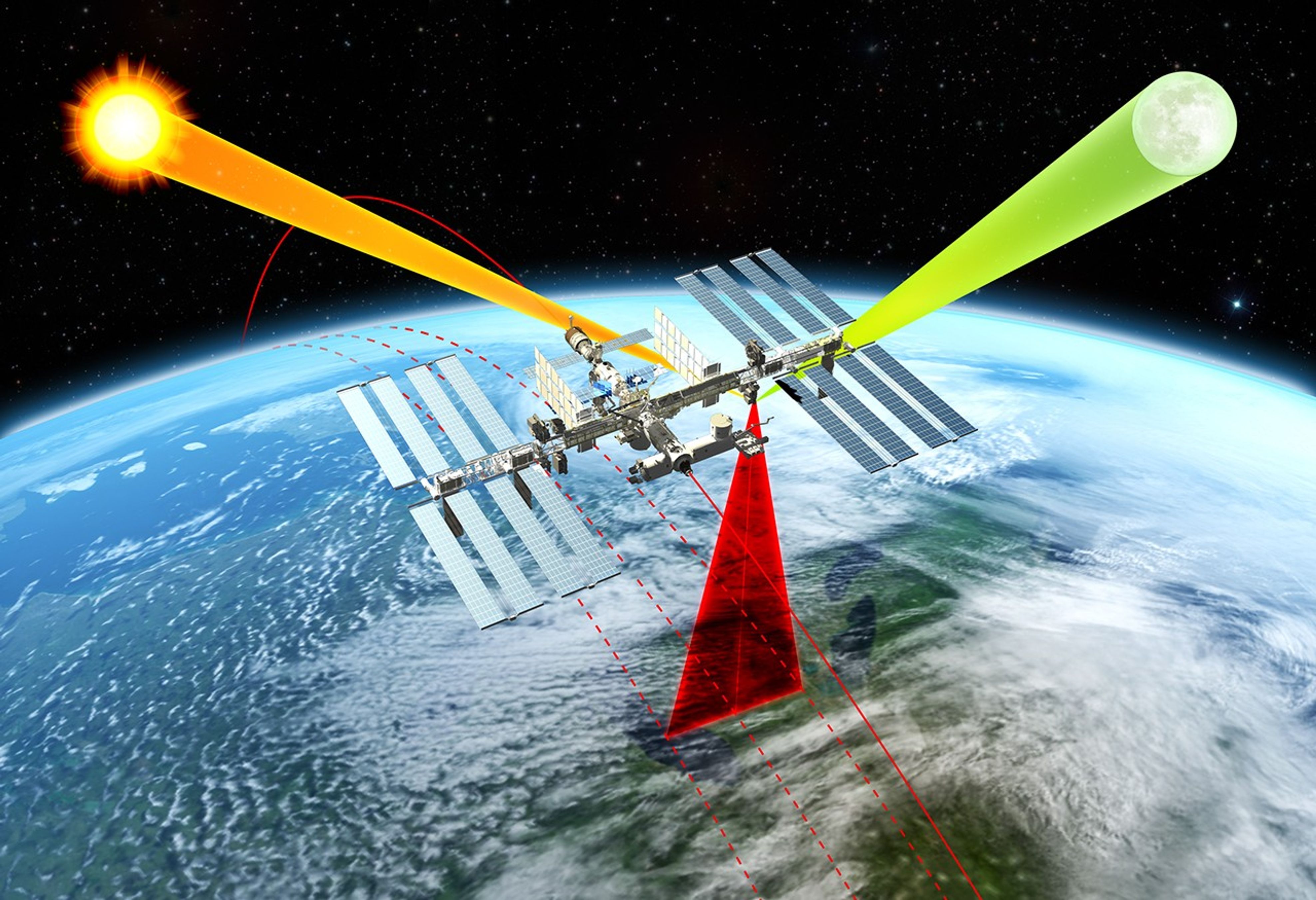
EARTH
Measuring sunlight reflected by Earth helps us learn about the Earth system. CLARREO Pathfinder has been designed to achieve unprecedented, high-accuracy measurements.

OTHER SATELLITES
CLARREO Pathfinder's high accuracy means that it can serve as an on-orbit reference for other satellite instruments. CLARREO Pathfinder demonstrates the capability to transfer its unparalleled high accuracy to other Earth-viewing satellites using a novel inter-calibration technique. This improves accuracy and consistency among satellite measurements.

THE MOON
The surface of the Moon is a highly stable reference that researchers use to track satellite sensor performance throughout the sensor’s lifetime. This is done by measuring the amount of sunlight that reflects off the Moon. Having highly accurate measurements of the Moon from space that are tied to international standards, improves this key calibration standard for a large number of Earth-monitoring instruments.

CONTINUOUS MEASUREMENT RECORDS
Continuous measurement records capture variability across long time spans by combining overlapping observations from multiple instruments. While overlapping measurements help extend records, any gaps limit the continuity and reliability of the record. CLARREO Pathfinder's high accuracy reduces this susceptibility to gaps, strengthening the long-term data record.

SOCIETAL BENEFITS
A clearer understanding of the Earth system’s variability provides policymakers with the information needed to more effectively decide how to respond to extreme natural disasters such as rising sea levels, a concern that impacts the U.S. military and coastal communities.

Latest CLARREO Pathfinder News

NASA’s Calibration Absolute Radiance and Refractivity Observatory Pathfinder, or CLARREO Pathfinder mission, reached a significant milestone this summer by achieving…
NASA’s Calibration Absolute Radiance and Refractivity Observatory Pathfinder (CLARREO Pathfinder) instrument was installed onto the International Space Station’s ExPRESS Logistics…

On Friday, May 15, NASA’s Calibration Absolute Radiance and Refractivity Observatory Pathfinder (CLARREO Pathfinder) instrument launched aboard a SpaceX Dragon…