CLARREO Pathfinder: Science Overview
CLARREO Pathfinder's Science Goals
The CLARREO Pathfinder mission has been designed to take shortwave (visible and near-infrared) measurements with sufficiently high accuracy such that they have the ability to more rapidly detect long-term trends than we can currently [Wielicki et al., 2013]. To address this critical need, CLARREO Pathfinder will strive to meet its two mission objectives: (1) To demonstrate on-orbit, SI-traceable calibration in measuring spectral reflectance (350-2300 nm), achieving an advancement in accuracy (by 5-10x) over existing sensors [Kopp et al., 2017]; and (2) To demonstrate the ability to use that unparalleled accuracy to serve as an on-orbit reference spectrometer for inter-calibration of other Earth-observing reflected solar satellite sensors [Lukashin et al., 2013].
Unparalleled Accuracy
The spectral range of HySICS (350 – 2300 nm) includes over 95% of the solar radiation reflected by the Earth. Energy within this spectral range drives critical processes including radiative forcing, the Earth system’s response, and critical geophysical feedbacks. This is why detailed knowledge of the instrument’s calibration accuracy and how it changes in orbit is essential for observing the long-term trends of essential geophysical variables that drive and respond to the variability of the Earth system. Another key benefit from CLARREO Pathfinder measurements is the high amount of information provided by the continuous spectral sampling of 3 nm across its spectral range.
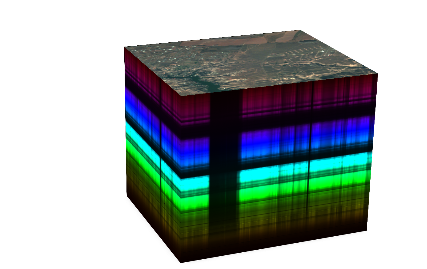
Measurements from a hyperspectral imager like HySICS are typically formatted in what is called a data cube (see the image below). The top face of the cube is a representation of the spatial scene, usually a red-green-blue (RGB) composite similar to a picture taken using a digital camera. But unlike a digital camera or even a typical space-borne imager that acquire measurements at just a few wavelengths, the CLARREO Pathfinder hyperspectral imager makes measurements at several hundred contiguous (neighboring) wavelengths that span most of the solar spectrum. The different wavelengths are represented by a third dimension, making a cube, such as the one below. Peeling off successive “layers” of the cube would reveal images of the same spatial scene at a different wavelengths. Depending on the scene type – for example, clouds, gases, and aerosol particles in the atmosphere, or vegetation, desert, or ocean at the surface – the layers of the cube from different wavelengths provide key information that enable us to determine atmospheric and surface composition far beyond what is possible from a handful of wavelengths.
Novel Inter-Cal Approach
The breakthrough advancement in absolute radiometric accuracy enables the CLARREO Pathfinder payload to serve as an on-orbit reference for other instruments that take measurements within the same spectral range. Inter-calibration of CLARREO Pathfinder with satellites like CERES and VIIRS can lead to improved calibration parameters on-orbit including sensor offset, gain, linearity, spectral response changes, and polarization sensitivity. This capability demonstration provides benefits across Earth science because inter-calibration with other instruments results in more accurate data products for more advanced monitoring of Earth and for testing and improving general circulation models.
CLARREO Pathfinder Data Products
CLARREO Pathfinder data will be publicly available from the Atmospheric Science Data Center (ASDC), which has been assigned as the mission’s Distributed Active Archive Center. There are three types of data products that will be distributed, as shown in the table below. The L1B data products will include the nominal nadir measurements and scheduled inter-calibration measurements. The inter-calibration measurements are scheduled to overlap Low-Earth Orbiting satellite sensors, one geostationary instrument (TBD), and lunar events. The inter-calibration team is also capable of providing locations of the nadir measurements that pass over vicarious calibration land surface sites often used by reflected solar instrument teams to monitor the stability of their instruments. Level 4 merged inter-calibration data products will contain all parameters needed to conduct inter-calibration data analysis.
| DATA PRODUCT | DESCRIPTION | BETA DATA RELEASE |
| Level 0 | Raw image (in Digital Numbers – DN) science and telemetered data taken by the instrument with associated telemetry data | Launch + 6 months |
| Level 1A | Radiometrically calibrated and geolocated spectral radiance and reflectance at full spatial resolution. Includes on orbit calibration, nadir, inter-calibration, lunar measurements. | Launch + 10 months |
| Level 1B | From Level 1A data product, nadir measurements will be spatially and spectrally resampled to nearly consistent sampling. | Launch + 10 months |
| Level 4 | Time/angle/space-matched inter-calibration data for reference (CLARREO Pathfinder) and target sensors (CERES and VIIRS). Includes data from target sensors to characterize inter-calibration scenes, necessary inter-calibration parameters, and parameters for estimating VIIRS polarization sensitivity. | Launch + 12 months |
L0, L1A, & L1B data products will be developed by the instrument and calibration team at LASP; L4 data products will be developed by the inter-calibration team at NASA Langley.