


![Request for Information – Potential [Placeholder for Prize]](https://assets.science.nasa.gov/dynamicimage/assets/science/psd/solar/2023/09/s/solarsystem_0.jpg?w=1024)


Quick Facts
Launched July 30, 2025 from the Satish Dhawan Space Centre in India
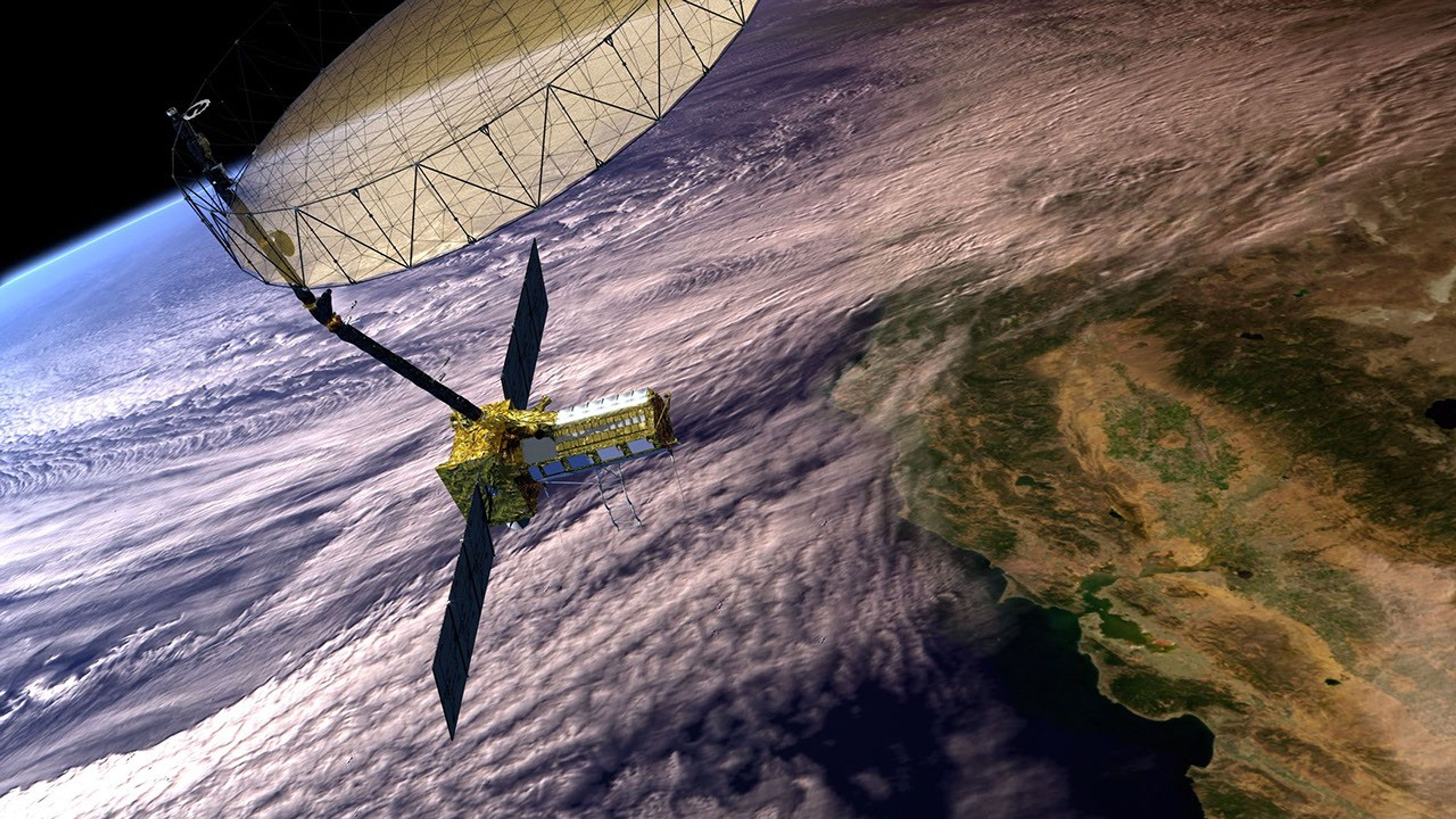
The NASA-ISRO SAR (NISAR) Mission will monitor changes in Earth’s land, water, vegetation, and ice to better understand processes such as vegetation change, natural hazards, sea level variation, and groundwater movement. It will also support a host of societal benefits. NISAR will collect global observations of land and ice-covered regions every 12 days from both ascending and descending orbits, providing an average revisit time of about 6 days over a planned three-year mission.
NISAR will observe Earth’s land and ice-covered surfaces globally with 12-day regularity on ascending and descending passes, sampling Earth on average every 6 days for a baseline 3-year mission.
Mission Characteristics
| NISAR | NASA, ISRO Synthetic Aperture Radar |
| Partnership | NASA and the Indian Space Research Organization (ISRO) |
| Launched | July 30, 2025 (from the Satish Dahwan Space Centre in India) |
| Orbit Altitude | 747 km |
| Orbit Inclination | 98.4° |
| Exact Repeat Cycle | 12 days |
| Time of Nodal Crossing | 6 AM (ascending) / 6 PM (descending) |
| Orbit Control | Less than 500 m |
| Look Direction | Left (south) |
| Baseline Mission Duration | 3 years |
| Data and Product Access | Free & open |
| Wavelengths | L-band: 24 cm S-band: 9.4 cm |
| SAR Resolution | 3–10 meter (acquisition mode-dependent) |
| Data Access | Alaska Satellite Facility (L-band) and Bhoonidhi (S-band and L-band over India and select sites around the world only) |
| Coverage | Global |
| Data Acquisitions | L-band Global, S-band (India and over cal/val sites) |
| Derived Products (L3) | Soil Moisture (Global at 200 meters spatial resolution over most areas and at 400 meters over the Sahara) |
| L1 and L2 Data | Radiometrically terrain corrected amplitude data, unwrapped interferograms |
| Mass | 2.8 metric tons |
Timeline
There are four phases of the NISAR mission, as shown in the graph below.
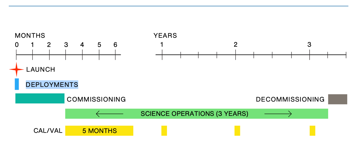
Each phase consists of:
Launch Phase: NISAR was launched on July 30, 2025, from the Satish Dhawan Space Centre (SDSC), also known as the Sriharikota High Altitude Range (SHAR), located on the southeast coast of India. The mission was launched with the GSLV Mark II launch vehicle, provided by ISRO.
The launch sequence spanned the period from liftoff, when the observatory was enclosed within the launch vehicle fairing, through spacecraft separation, and concluded with successful solar array deployment, establishment of an Earth-pointed attitude, and two-way communication with ground stations.
Commissioning Phase: Following its launch on July 30, 2025, NISAR entered the commissioning phase. During this period, spacecraft systems were checked to ensure proper operation, and mission controllers established routine communication and control.
Key milestones included deployment of the reflector boom and antenna, final orbit adjustments, and full instrument activation and checkout. Ground systems were also brought online to support routine data processing. During this phase the first NISAR image was released to the public.
Science Operations Phase: In early January 2026, NISAR entered its science operations phase. During this phase, the satellite begins routine, long-term collection of scientific data for research and applications. The science orbit is maintained through regular maneuvers. In addition, extensive calibration and validation (cal/val) activities are conducted during the first months of the mission, followed by annual updates lasting approximately one month.
This phase includes three years of primary science operations required by NASA, followed by potential extended operations led by ISRO or continued through NASA’s Senior Review process.Decommissioning Phase: This 90-day phase is the final stage of the mission, during which the satellite is safely retired after completing its science objectives. The spacecraft is placed into a disposal orbit and passivated to ensure it does not become a hazard in space.


