


Venus Gallery
Catalog of images, videos, and animations of the Venus.
Latest Venus Content
Stay up-to-date with the latest content about the Venus from Photojournal
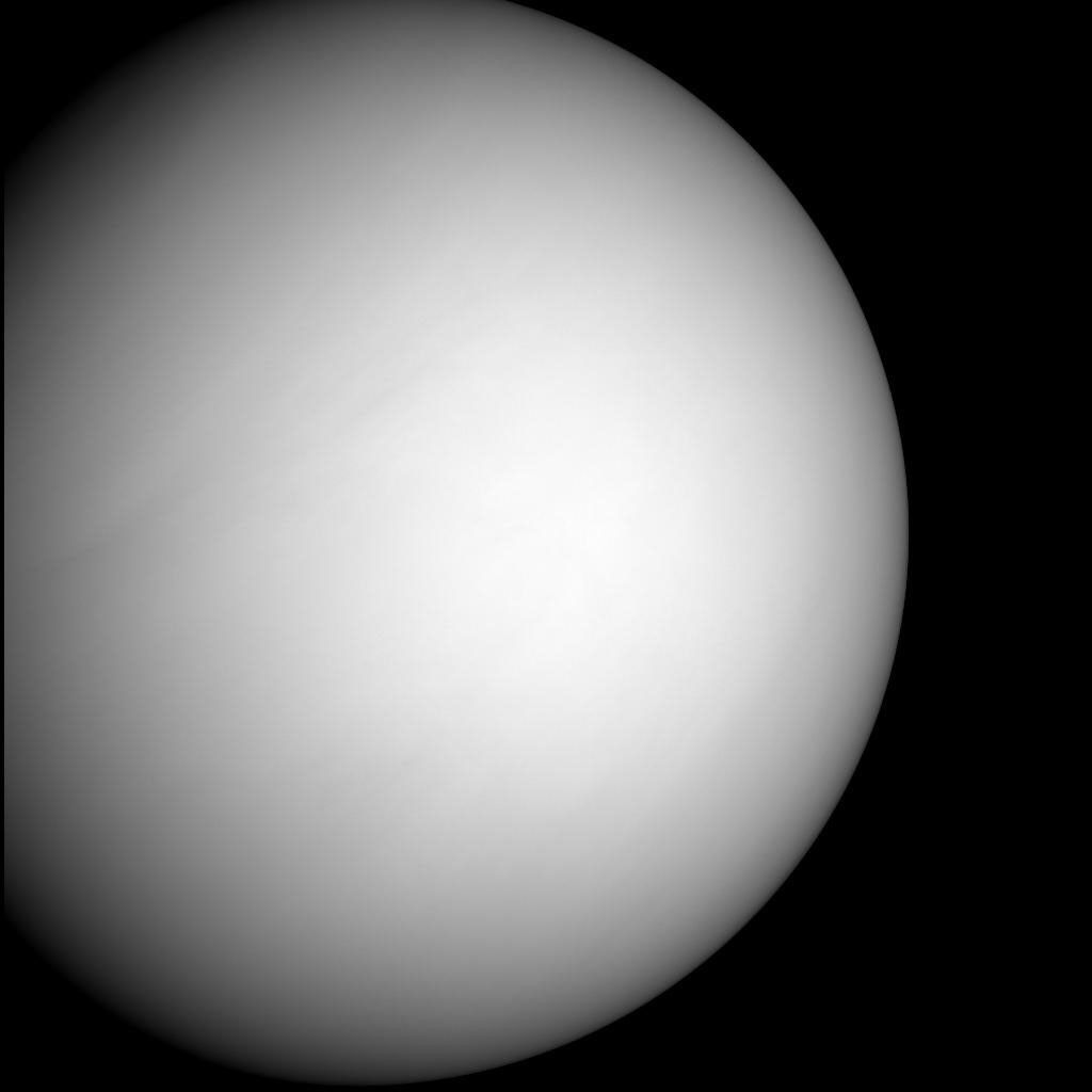
As it sped away from Venus, NASA's Mariner 10 spacecraft captured this seemingly peaceful view of a planet the size…

Observations of the total solar irradiance made with the ACRIM3 instrument on NASA's ACRIMSAT satellite on June 5 and 6,…
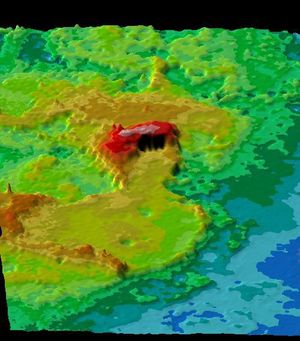
This figure shows the volcanic peak Idunn Mons in the Imdr Regio area of Venus. The topographic backbone (brown color)…

This image from NASA's MESSENGER is one of many from the latest vulcanoid search are currently being transmitted to Earth.…

After acquiring hundreds of high-resolution images during close approach to Venus, NASA's MESSENGER turned its wide-angle camera back to the…

NASA's MESSENGER spacecraft snapped a series of images as it approached Venus on June 5. The planet is enshrouded by…

On Oct. 24, 2006, NASA's MESSENGER spacecraft came within 2,990 kilometers (1,860 miles) of Venus during its second planetary encounter.

NASA's Mariner 2 was the world's first successful interplanetary spacecraft. Launched August 27, 1962, on an Atlas-Agena rocket, Mariner 2…
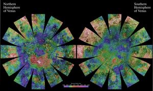
The images used for the base of this globe show the northern and southern hemispheres of Venus as revealed by…
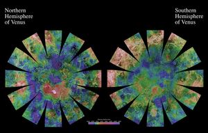
The images used for the base of this globe show the northern and southern hemispheres of Venus as revealed by…

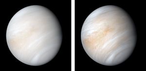
Venus Cloud Tops Viewed by Hubble. This is a NASA Hubble Space Telescope ultraviolet-light image of the planet Venus, taken…

This perspective view of Venus, generated by computer from NASA's Magellan data and color-coded with emissivity, is a look westward…

This perspective view of Venus, generated by computer from NASA's Magellan data and color-coded with emissivity, is a look westward…

This perspective view of Venus, generated by computer from NASA's Magellan data and color-coded with emissivity, shows part of the…

This perspective view of Venus, generated by computer from NASA's Magellan data and color-coded with emissivity, shows part of the…

This perspective view of Venus, generated by computer from NASA's Magellan data and color-coded with emissivity, shows the impact crater…

This perspective view of Venus, generated by computer from NASA's Magellan data and color-coded with emissivity, shows the boundary between…

This perspective view of Venus, generated by computer from NASA's Magellan data and color-coded with emissivity, shows the boundary between…

This perspective view of Venus, generated by computer from NASA's Magellan data and color-coded with emissivity, shows the boundary between…

This perspective view of Venus, generated by computer from NASA's Magellan data and color-coded with emissivity, shows part of the…

This perspective view of Venus, generated by computer from NASA's Magellan data and color-coded with emissivity, shows part of the…

This perspective view of Venus, generated by computer from NASA's Magellan data and color-coded with emissivity, shows part of Sedna…

The view of Venus, after more than a decade of radar investigations culminating in the 1990-1994 NASA Magellan mission, is…
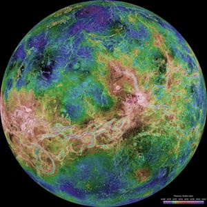
The view of Venus, after more than a decade of radar investigations culminating in the 1990-1994 NASA Magellan mission, is…

The hemispheric view of Venus, as revealed by more than a decade of radar investigations culminating in NASA's 1990-1994 Magellan…

The hemispheric view of Venus, as revealed by more than a decade of radar investigations culminating in NASA's 1990-1994 Magellan…

The view from NASA's Magellan spacecraft shows a 100-km-wide nova superposed on Yavine Corona. Coronae are roughly circular, volcanic features…

The view from NASA's Magellan spacecraft shows Yavine Corona, looking northeast. Coronae are roughly circular, volcanic features believed to form…

This view from NASA's Magellan spacecraft is a close-up of Atete Corona, a 600-km-long and 450-km-wide feature at latitude 16…

The view from NASA's Magellan spacecraft shows most of Galindo (V-40) quadrangle looking east; Atete Corona, in the foreground, is…

The view from NASA's Magellan spacecraft shows part of Galindo (V40) quadrangle looking north; Nagavonyi Corona is in the foreground.…
This perspective view of Ishtar Terra was derived from data obtained by NASA's Pioneer Venus spacecraft's altimetry radar instrument.

This composite image was created by inserting approximately 70 orbits of NASA's Magellan data into an image obtained at the…

A portion of Alpha Regio is displayed in this three-dimensional perspective view of the surface of Venus from NASA's Magellan…

Crater Isabella is seen in this radar image from NASA's Magellan spacecraft. The second largest impact crater on Venus, the…

This image from NASA's Magellan spacecraft is from the northeastern Atalanta Region of Venus. The image shows the complex impact…

This synthetic aperture radar mosaic from NASA's Magellan spacecraft is a global view of the surface of Venus.

This full resolution mosaiced image from NASA's Magellan spacecraft is located in the Lakshmi region of Venus at 47 degrees…

This image from NASA's Magellan spacecraft shows an irregular crater of approximately 14- kilometer (8.7-mile) mean diameter. The crater is…

This image from NASA's Magellan spacecraft is of Crater Stephania in northern Sedna Planitia on Venus. It is one of…

This image from NASA's Magellan spacecraft is of the eastern Navka Region of Venus. The crater, which is approximately 8…

This image from NASA's Magellan spacecraft is of Sachs Patera on Venus. Defined as a sag-caldera, Sachs is an elliptical…

This full-resolution image from NASA's Magellan spacecraft shows an impact crater named Jeanne. The distinctive triangular shape of the ejecta…

This image from NASA's Magellan spacecraft is from the eastern Ovda region of Venus. The image shows some small volcanic…

This image from NASA's Magellan spacecraft reveals Sacajawea Patera, a large, elongate caldera located in Western Ishtar Terra on the…

This radar image mosaic of Venus from NASA's Magellan spacecraft, is in the Lada region. The mosaic shows a system…

This image from NASA's Magellan spacecraft is from the southern portion of Navka. In the center of this image are…

Sapas Mons is displayed in the center of this computer-generated three-dimensional perspective view from NASA's Magellan spacecraft of the surface…

This false color image from NASA's Magellan spacecraft shows a portion of Leda Planitia (plains) in the northern hemisphere of…

This global view from NASA's Magellan spacecraft is of the surface of Venus is centered at 180 degrees east longitude.

Three impact craters are displayed in this three-dimensional perspective view from NASA's Magellan spacecraft of the surface of Venus. The…

A portion of western Eistla Regio is displayed in this three-dimensional perspective view from NASA's Magellan spacecraft of the surface…

This image from NASA's Magellan spacecraft shows an area of dark volcanic lava flows overlying the brighter surrounding plains which…

This is a full resolution mosaic from NASA's Magellan spacecraft showing a series of complex lava flows which emerge from…

This image from NASA's Magellan spacecraft covers region near Hestia Rupes on the northwestern corner of Aphrodite Terra. This complex…

This crater in the Navka region of Venus was mapped by NASA's Magellan on Sept. 26-27, 1990 during orbits 459…

In September 1990, Magellan imaged this impact crater that is representative of Venusian craters that are of the proper diameter…

This image from NASA's Magellan spacecraft is in the Lavinia Region of Venus. Volcanic vent areas in this part of…

The eastern half of the planet is displayed in this simple cylindrical map of the surface of Venus obtained by…

The western half of the planet is displayed in this simple cylindrical map of the surface of Venus obtained by…

This image from NASA's Magellan spacecraft shows an impact crater in the central Eistla Region of the equatorial highlands of…

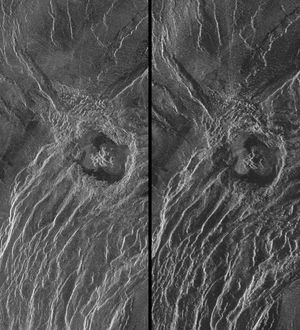
These radar images show an identical area on Venus as imaged by the NASA's Magellan spacecraft in 1991 (left) and…

This image covers part of a deep valley on Venus called Devana Chasma. The image is a composite of the…

During orbits 404 through 414 on 19-20 September 1990, NASA's Magellan spacecraft imaged a peak-ring crater.

NASA's Magellan spacecraft imaged this multiple-floored, irregular impact crater at latitude 16.4 degrees north, longitude 352.1 degrees east, during orbits…

This mosaic of NASA's Magellan data in the Fortuna region of Venus. Shown here are Bahet Corona on the left,…

This image from NASA's Magellan spacecraft is a mosaic of 24 orbits of the Navka region of Venus. Volcanic domes…

The northern hemisphere is displayed in this global view of the surface of Venus as seen by NASA's Magellan spacecraft.

This full resolution radar mosaic from NASA's Magellan spacecraft shows a 200 kilometer (124 mile) segment of a sinuous channel…

This image from NASA's Magellan shows part of the interior of Ovda Regio, one of the large highlands ringing the…

This mosaic from NASA's Magellan data is in the Lavinia region of Venus. Three large impact craters can be seen…

A portion of western Eistla Regio is shown in this three dimensional, computer-generated view of the surface of Venus. This…

This image covers much of Ovda Regio, which forms the western part of Aphrodite Terra captured by NASA's Magellan spacecraft.
This spectacular image from NASA's Magellan spacecraft is centered on 30 degrees south latitude, 135 degrees east longitude, spans 3500…

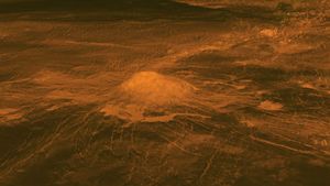
Maat Mons is displayed in this computer generated three-dimensional perspective of the surface of Venus. This NASA Magellan image was…

Ushas Mons, a volcano in the southern hemisphere of Venus is shown in this radar image from NASA's Magellan spacecraft.…

The northern hemisphere is displayed in this global view of the surface of Venus as seen by NASA's Magellan spacecraft.

This hemispheric view of Venus, as revealed by more than a decade of radar investigations culminating in the 1990-1994 Magellan…

This hemispheric view of Venus, as revealed by more than a decade of radar investigations culminating in the 1990-1994 Magellan…
This is a stereo image pair of crater Goeppert-Mayer obtained by NASA's Magellan radar mapping mission.

This computer-generated perspective view of Latona Corona and Dali Chasma on Venus shows NASA's Magellan radar data superimposed on topography.

This set of three images from NASA's Magellan spacecraft, shows a small volcano, lava plains distorted into 'wrinkle ridges,' and…

This full resolution radar mosaic from NASA's Magellan spacecraftshows an oblique view of the impact crater Riley, named for Margaretta…

This full-resolution mosaic of Venus, obtained by NASA's Magellan spacecraft, shows an area replete with diverse volcanic features.

This is full-resolution mosaic from NASA's Magellan spacecraft. The bright feature, slightly south of center is interpreted to be a…

NASA's Magellan spacecraft has observed remnant landslide deposits apparently resulting from the collapse of volcanic structures.

NASA's Magellan spacecraft observed remnant landslide deposits apparently resulting from the collapse of volcanic structures. This radar image is centered…

This image from NASA's Magellan spacecraft, with radar illumination from west to east, shows three unusual volcanoes located in the…

As NASA's Magellan mission progressed, areas of Venus became accessible for a second look. During Magellan's second 243-day global mapping…

This false color image from NASA's Magellan spacecraft shows a portion of Bereghinya Planitia (plains) in the northern hemisphere of…

This false color Magellan image shows a portion of Eistla Regio (region) in the northern hemisphere of Venus, centered at…

This global view of the surface of Venus is centered at 0 degrees east longitude. NASA's Magellan synthetic aperture radar…

Maat Mons is displayed in this 3-dimensional perspective view of the surface of Venus taken by NASA Magellan. The viewpoint…

The northern hemisphere is displayed in this global view of the surface of Venus. NASA's Magellan synthetic aperture radar mosaics…

NASA's Magellan image depicts a stereoscopic pair of an area on Venus with small volcanic domes. Stereoscopic images of Venus…

This full-resolution image from NASA's Magellan spacecraft shows the northern part of the Akna Montes (mountains) of Venus.

Southwest Lakshmi Planum (plains) is bounded on the south by the Danu Montes (mountains) as shown by NASA's Magellan spacecraft.

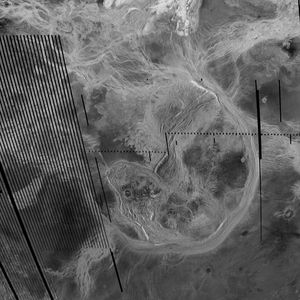
Landslides on Venus! The image on the left was taken in late November of 1990 during Magellan's first trip around…

These two radar images from NASA's Magellan spacecraft are centered about 60.5 degrees south latitude and 348.8 degrees east longitude…

A portion of the eastern edge of Alpha Regio is displayed in this three-dimensional perspective view of the surface of…


