


Description
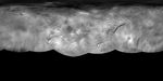
The science team of NASA's New Horizons mission has produced this global map of Pluto's largest moon, Charon. The map includes all available resolved images of the surface acquired between July 7-14, 2015, at pixel resolutions ranging from 40 kilometers (24 miles) on the anti-Pluto facing hemisphere (left and right sides of the map), to 400 meters (1,250 feet) per pixel on portions of the Pluto-facing hemisphere -- the side facing the New Horizons spacecraft when it flew past the dwarf planet -- at map center. Many additional images now stored on the spacecraft's digital data recorders are expected to be transmitted "home" in fall 2015 and these will be used to complete the global map. The map is in simple cylindrical projection, with zero longitude (the Pluto-facing direction) in the center.
The Johns Hopkins University Applied Physics Laboratory in Laurel, Maryland, designed, built, and operates the New Horizons spacecraft, and manages the mission for NASA's Science Mission Directorate. The Southwest Research Institute, based in San Antonio, leads the science team, payload operations and encounter science planning. New Horizons is part of the New Frontiers Program managed by NASA's Marshall Space Flight Center in Huntsville, Alabama.


