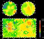
Photojournal NavigationSciencePhotojournalMars Gravity Map (RS)Photojournal HomePhotojournal SearchLatest ContentGalleriesFeedbackRSSAbout 1 Min Read Mars Gravity Map (RS) PIA02054 Credits: NASA/JPL/GSFC Image Addition Date:06/23/1999Target:MarsIs a satellite of:SunMission(s):MGS (Mars Global Surveyor)Spacecraft(s):Mars Global Surveyor (MGS)Instrument(s):Radar SystemDataset:MGS (Mars Global Surveyor) Downloads Mars Gravity Map (RS) JPEG (603.58 KB) Mars Gravity Map (RS) TIFF (4.36 MB) Description Vertical gravity map of Mars color-coded in mgals based on radio tracking. Note correlations and lack of correlations with the global topography. Keep Exploring Discover More Topics From Photojournal Photojournal Search Photojournal Photojournal’s Latest Content Feedback