


Description
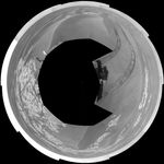
NASA's Mars Exploration Rover Opportunity used its navigation camera to take the images combined into this full-circle view of the rover's surroundings during the 1,803rd and 1,804th Martian days, or sols, of Opportunity's surface mission (Feb. 18 and 19, 2009). South is at the center; north at both ends.
The rover had driven 55 meters on Sol 1803 before beginning to take the frames in this view. Tracks from that drive recede northward. For scale, the distance between the parallel wheel tracks is about 1 meter (about 40 inches).
The terrain in this portion of Mars' Meridiani Planum region includes dark-toned sand ripples and lighter-toned bedrock.
This view is presented as a polar projection with geometric seam correction.


