


Description
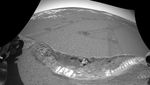
This image taken by the navigation camera on the Mars Exploration Rover Opportunity shows the crater floor at Meridiani Planum, Mars, after the rover dug a trench on sol 23 (February 16, 2004). Scientists used the microscopic imager, an instrument located on the rover's instrument deployment device, or "arm," to take a picture of the small patch of soil in the center of the trench wall. Here, that microscopic image has been overlaid to show where that patch of soil, which measures approximately 3 centimeters (1.2 inches) across, is located.


