


Description
28 September 2006
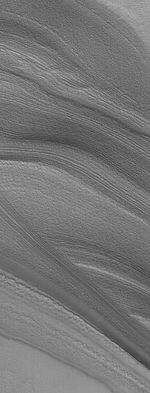
This Mars Global Surveyor (MGS) Mars Orbiter Camera (MOC) image shows layers exposed in the north polar region of Mars. The north polar cap is underlain by a thick sequence of layered material. The layers are most commonly exposed on the slopes of troughs that are believed to have formed by wind erosion. The layers give a banded appearance. In this example, some of the layers are cut off (truncated) by other layers. This truncation is a classic, textbook example of an erosional unconformity, a term commonly used by geologists. The unconformity occurs when deposition of new layered material stops for a while, and erosion occurs. Then, new layers form on top of the eroded surface and the older layers, at some point in time when the erosion stops and deposition of layered material resumes.
Location near: 78.6°N, 342.0°W
Image width: ~3 km (~1.9 mi)
Illumination from: lower right
Season: Northern Spring


