


Description
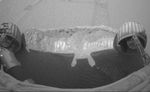
The Mars Exploration Rover Opportunity dragged one of its wheels back and forth across the sandy soil at Meridiani Planum to create a hole (center) measuring approximately 50 centimeters (19.7 inches) long by 20 centimeters (7.9 inches) wide by 9 centimeters (3.5 inches) deep. The rover's instrument deployment device, or arm, will begin studying the fresh soil at the bottom of the trench later today for clues to its mineral composition and history. Scientists chose this particular site for trenching because previous data taken by the rover's miniature thermal emission spectrometer indicated that it contains crystalline hematite, a mineral that sometimes forms in the presence of water. The brightness of the newly-exposed soil is thought to be either intrinsic to the soil itself, or a reflection of the Sun. This image was taken by the rover's hazard-avoidance camera.


