Cassini Takes Final OpNav Image
| Credit | NASA/JPL-Caltech/Space Science Institute |
|---|---|
| Language |
|
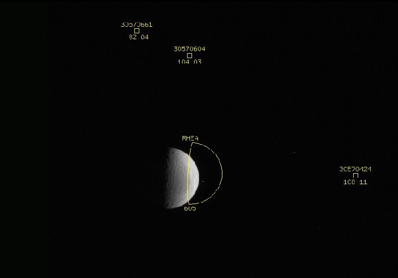
On Tuesday, Sept. 20, 2016, the Cassini spacecraft took its final optical navigation, or OpNav, image of the mission. Throughout its journey Cassini has used its narrow angle camera to capture images of Saturn’s moons against backgrounds of known stars to precisely determine the spacecraft’s course, as well as the moon’s. In all, the spacecraft has taken 2,817 images solely for navigation purposes since launching in 1997.
But for Cassini’s final 11 months before diving into Saturn’s atmosphere, it will navigate using only the Doppler shift and timing of radio signals to and from Earth. Cassini will, however, continue collecting images for scientific purposes. Without OpNav images, the Cassini team would not have attempted such daring feats as flying through the plume of the icy moon Enceladus just 16 miles (25 kilometers) from its surface.
In the above image, the yellow squares identify the positions of known stars, and the yellow half-circle shows where the moon Rhea was expected to be. The difference between the expected and observed position of Rhea can be used to refine our understanding of the moon’s precise orbit around Saturn.
Read more about how Cassini navigates, and how the cameras work.
The Cassini mission is a cooperative project of NASA, ESA (the European Space Agency) and the Italian Space Agency. The Jet Propulsion Laboratory, a division of the California Institute of Technology in Pasadena, manages the mission for NASA's Science Mission Directorate, Washington. The Cassini orbiter and its two onboard cameras were designed, developed and assembled at JPL. The imaging operations center is based at the Space Science Institute in Boulder, Colorado.
For more information about the Cassini-Huygens mission visit http://saturn.jpl.nasa.gov and http://www.nasa.gov/cassini. The Cassini imaging team homepage is at http://ciclops.org.


