


.png?w=1024)


Landsat 7
Filters

Wild disturbances are on the rise, while land disturbed by human activity has been decreasing.

Satellites have tracked development over the decades as a small city in southern Nigeria grew to more than 2 million…

Satellite data show decades of gradual but persistent change to forests around one of the Democratic Republic of the Congo’s…
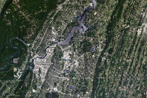
Signs of urban expansion cover parts of Tennessee’s “scenic city,” which is nestled along the meandering Tennessee River.

The iconic trees and shrubs of the Florida Everglades are under increased stress due to more frequent, intense hurricanes.

Scientists are beginning to unravel what comes next, after the ice moves out and vegetation moves in.

Decades of satellite data paint a picture of how forests in this Central American country are changing.

The largest tropical rainforest in Mesoamerica is shrinking as pastures and croplands spread across Guatemala, Belize, and Mexico. Â

Over the past two and a half decades, EO has published more than 15,000 image-driven stories. This video highlights some…
