![Request for Information – Potential [Placeholder for Prize]](https://assets.science.nasa.gov/dynamicimage/assets/science/missions/a-step/FFR_Earth_Background_20251120%20.png?w=1024)


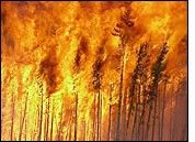
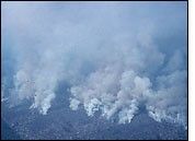
Forest fires, brush fires, and slash and burn agriculture—types of biomass burning—are a significant force for environmental change, both locally and globally. Intentional deforestation by burning radically alters local landscapes. At regional scales, fires naturally shape ecosystems such as the boreal forest (Canada, Alaska, and Russia) and chapparral (Southern California). Globally, fires may play an important role in climate change, emitting both greenhouse gases and smoke particles (aerosols) into the atmosphere. These emissions almost certainly played a role in the 0.5° Celsius increase in the Earth's average surface temperature over the past 100 years.
Current global estimates of gas and particulate (aerosol) emissions from biomass burning in the open literature are extremely approximate and vary considerably:
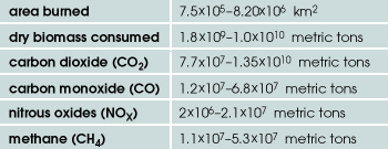
These emission products promote the formation of polluted clouds and affect the Earth's radiant energy budget (heat and sunlight) in ways that influence climate on a regional and global scale.
Fire has always been and continues to be an integral part of land use and culture around the World. Earth Scientists are placing greater emphasis on obtaining more accurate assessments of emissions from biomass burning. Remote sensing of fires, smoke and even burn scars (transformed area where the fire burned) allows for improved detection of fire characteristics as well as their short- and long-term effects on ecosystems.
Why are Fires Important?
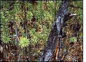
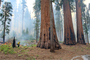
Fires play an important role in the natural changes that occur in Earth's ecosystems. The diversity of plant and animal life in the world's forests, prairies, and wetlands is (partly) dependent on the effects of fire; in fact, some plants cannot reproduce without fire (fire breaks open the outside coating of some seeds and stimulates germination). What may at first look like total devastation soon becomes a panorama of new life. Fire initiates critical natural processes by breaking down organic matter into soil nutrients. Rain then moves these nutrients back into the soil providing a rejuvenated fertile seedbed for plants. With less competition and more sunlight, seedlings grow more quickly.
Wild animals deal with fire remarkably well. Birds fly out of the fire area, large animals leave the danger zone by escaping to ponds and streams, while others return to their burrows. Usually few animals are killed by fire.
Prescribed fire is one of the most important tools used today to manage Earth's diverse ecosystems. A scientific prescription, prescribed fires help create a mosaic of diverse habitats for plants and animals. If all fire is suppressed, fuel (grasses, needles, leaves, brush, and fallen trees) can build up and allow larger, and sometimes uncontrollable, fires to occur. If enough fuel builds up, the fires could be so intense that they may destroy the seeds in the soil and hinder new tree and plant growth. By burning away accumulated fuels, planned fires make landscapes safer for future natural fires.
State of the Science
By 1990, global tropical deforestation was occurring at a rate of about 1.8 percent of the world's total forest lands per year. Approximately 142,000 square kilometers of rainforest are eliminated annually—an area slightly larger than the state of Arkansas (more information on this topic can be found in the Tropical Deforestation Fact Sheet). Using data from satellite sensors, aircraft, and ground-based initiatives, scientists are working to develop a new global fire monitoring program that will enable them to better understand the myriad implications of this growing problem. Specifically, efforts are underway to quantify the total area of forests and grass land burned each year and to more precisely estimate the amount of resulting emission products. These newer and better data will facilitate development of more robust computer models that will enhance scientists' abilities to predict how biomass burning will impact climate, the environment, and air quality.
Trace Gas Emissions
Since the beginning of the industrial revolution, humans have transformed about 40 percent of Earth's land surface and have increased carbon dioxide levels by about 25 percent. Scientists estimate that from 1850 to 1980, between 90 and 120 billion metric tons (90-120 trillion kilograms) of carbon dioxide were released into the atmosphere from tropical forest fires. Comparatively, during that same time period, an estimated 165 billion metric tons of carbon dioxide were added to the atmosphere by industrial nations through the burning of coal, oil, and gas. Today, an estimated 5.6 gigatons of carbon are released into the atmosphere each year due to fossil fuel burning. Burning of tropical forests contributes another 2.4 gigatons of carbon per year; or, about 30 percent of the total.
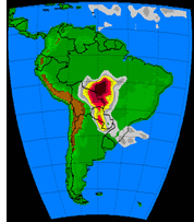
Over the last decade, it seems that the regional distribution of biomass burning has increased worldwide, as well as the length of burning time. The result is a continuing increase in the release of emission products, and an increase in the severity of their impact on climate and on the environment. Scientists estimate that in just a few months the burning that took place in 1997 in Indonesia released as many greenhouse gases as all the cars and power plants in Europe emit in an entire year.
After carbon dioxide, the most significant greenhouse gas is methane, another emission product from biomass burning (about 10 percent globally). Although methane is about 200 times less abundant than carbon dioxide in the atmosphere, molecule for molecule methane is 20 times more effective at trapping heat. Since the beginning of the Industrial Revolution, methane has doubled in the troposphere. Additionally, its concentration has been increasing about 1 percent per year, so scientists are concerned that its relative significance as a greenhouse gas may dramatically increase in the future, although there are indications that this increase may have slowed down in the last decade.
Nitrous oxide (N2O) concentrations have been increasing at about 0.3 percent per year for the last several decades. Yet, nitrous oxide has a lifetime of 150 years in the atmosphere, which contrasts sharply with the 10-year lifetime of methane. A single nitrous oxide molecule is the equivalent of 206 carbon dioxide molecules in terms of its greenhouse gas effect. Biomass burning accounts for about 2-3 percent of the total amount of tropospheric nitrous oxide. Emissions of nitrous oxides and methane are further associated with the production of tropospheric ozone. Unlike "good" ozone in the stratosphere (upper atmosphere) that acts as a shield to screen out the sun's harmful ultraviolet rays, ozone in the troposphere is a pollutant that, when breathed, damages lung tissue and is also harmful to plants.
Greenhouse gases—such as carbon dioxide, methane, and nitrous oxide—are mostly "transparent" to incoming solar radiation; that is, they rarely interact with sunlight. However, these gases are very efficient at trapping heat radiated from the Earth's surface by absorbing and re-emitting it.
There is a wide margin of error in the estimates of biomass burning given above—significantly more error than in our estimates of industrial emissions. The accuracy of scientist's biomass burning emission estimates must be improved if they are to better understand, model and predict the impacts of the emissions on climate change.
Aerosol Emissions
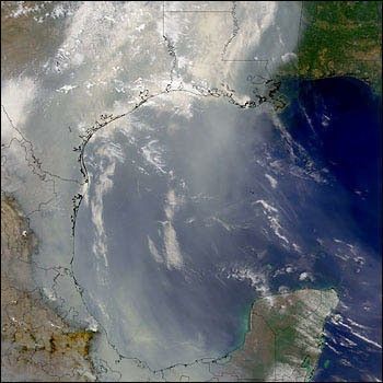
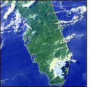
Smoke and aerosol particles from large-scale biomass burning can rise high into the troposphere and be carried long distances by wind currents. Smoke plumes from Mexico have traveled as far north as Wisconsin and the Dakotas, and as far east as Florida and out over the Gulf Stream.
Aerosols have a two-fold cooling effect on climate. In the open atmosphere, they scatter and absorb incoming solar radiation, thereby reducing the amount of sunlight that reaches the surface. Moreover, aerosols act as "seeds"—called cloud condensation nuclei. When clouds form in the polluted atmosphere, the clouds' droplets tend to be smaller and more numerous. Because polluted clouds are typically comprised of more densely-packed droplets, they are more efficient at absorbing and reflecting sunlight, again having a cooling effect on the surface.
Aerosols represent one of the greatest areas of uncertainty regarding climate change, both on global and regional scales. Scientists do not fully understand the magnitude of their cooling influence on climate.
Scientists do not know which of the emission products exerts the greater net effect on regional and global climate—the cooling influence of aerosols and clouds, or the warming influence of the greenhouse gases. Because both types of emission products change rapidly through time and space, they are difficult to observe and characterize. In the future, the greenhouse gas warming is expected to dominate due to the gases' much longer presence in the atmosphere (10-100 years) than that of aerosol particles (7 days).
NASA and NOAA Missions for Monitoring Global Fires
Different satellites provide observation and measurement capabilities for monitoring different fire characteristics: areas that are dry and susceptible to wildfire outbreak, actively flaming and smoldering fires, burned area, and smoke and trace gas emissions. Several satellite systems are currently available for fire monitoring with different capabilities in terms of spatial resolution, sensitivity, spectral bands, and times and frequencies of overpasses.
Fires vary widely in size, duration, temperature, and in the tropics, where it is moist and humid, fires have a strong diurnal cycle. No one system provides optimal characteristics for fire monitoring—multi-sensor data fusion is needed to optimize the use of current systems.
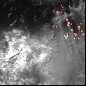
Flown on NOAA Polar Orbiting Environmental Satellites, the Advanced Very High Resolution Radiometer (AVHRR) measures electromagnetic radiation (light reflected and heat emitted) from our planet. AVHRR was originally intended only as a meteorological satellite system but it does have applications for fire monitoring. AVHRR remotely senses cloud cover and sea surface temperature, enabling its visible and infrared detectors to observe trends in vegetation, clouds, shorelines, lakes, snow and ice. The visible bands can detect smoke plumes from fires as well as burn scars. The thermal infrared band can detect actual hotspots and active fires. Its ability to detect fires is greater at night, since the system can confuse active fires with heated ground surfaces, such as beach sand and asphalt.
Active fire mapping on a global scale using a single satellite system has been coordinated by the International Geosphere Biosphere Program (IGBP) using AVHRR data for 1992-93 from international ground stations.
In addition, a small number of countries have developed their own regional AVHRR satellite fire monitoring systems using direct read-out; e.g., Brazil, Russia, and Senegal. Research groups have provided regional examples of trace gas and particulate emissions from fires for Brazil, Southern Africa, Alaska.
The Geostationary Operational Environmental Satellites (GOES) house a five-channel (one visible, four infrared) imaging radiometer designed to sense radiant and solar reflected energy from sample areas of the Earth. They are stationed in orbits that remain fixed over one spot on the equator, providing continuous coverage of one hemisphere. GOES satellites aquire images every 15–30 minutes, at up to 1km resolution in visible light, for the detection of smoke, and 4km resolution in thermal infrared to directly detect the heat of fires.
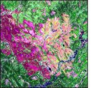
The Landsat series of Earth-observing satellites monitor characteristics and changes on the surface of the Earth at high resolution (up to 15m per pixel). The original missions (1970s – early 1980s) used the Multispectral Scanner (MSS) which was only capable of detecting scars. Current Landsat series satellites use the Thematic Mapper (TM) and Enhanced Thematic Mapper Plus (ETM+) to provide land surface information. The seven bands (eight on Landsat 7's ETM+) monitor different types of Earth resources over a wide area (81 North and 81 South Latitude). The thermal band enables the system to detect "hotspots." Landsat 7 provides impressive high-resolution images but only infrequently, revisiting an area every 14 days.
The Total Ozone Mapping Spectrometer (TOMS) is a measuring device that provides data regarding ozone levels. Measured in Dobson Units (DU), TOMS produces a complete data set of daily ozone levels around the world. This instrument is the first to show aerosols (airborne dust and smoke particles) over land. It also provides the ability to distinguish aerosols that absorb light from aerosols that reflect it. TOMS makes 35 measurements every 8 seconds, each covering 50-200 kilometers wide on the ground. Close to 200,000 daily measurements cover almost every spot on the Earth except for areas near the poles. These data make it possible to observe a variety of Earth events including forest fires, dust storms and biomass burning.
The Tropical Rainfall Measuring Mission (TRMM) carries a high-resolution sensor similar to AVHRR, called the Visible and Infrared Scanner (VIRS), which is capable of spotting active fires as well as evidence of burn scars. It has five bands from visible to thermal infrared (.63–12µm) and provides 2km resolution. TRMM's primary purpose is to measure rainfall over both land and oceans from 30° South to 30° North Latitude. TRMM is unique in that previous satellites tended to show the tops of clouds whereas TRMM instrumentation allows a look into the cloud itself. In addition to its other sensors, TRMM carries LIS, the Lightning Imaging Sensor. LIS provides information on both cloud to cloud and cloud to ground lightning strikes around the world. The imager is capable of locating and detecting ninety percent of lightning strikes in the world. This information can help identify areas that may be particularly susceptible to wildfire outbreaks.
In late 1999, NASA launches the first in a series of new Earth remote sensors that will bring dramatically improved capabilities for global monitoring of fires. The Earth Observing System's flagship spacecraft—Terra (formerly named EOS AM-1)—will carry a payload of five sensors that, collectively, greatly expand scientists' capacity for near-real-time fire monitoring, while more accurately measuring emission products. The Terra spacecraft will fly in a near-polar orbit, crossing the equator in the morning when cloud cover is at a minimum and its view of the surface is least obstructed. Subsequently, in 2000, the Aqua (formerly EOS PM-1) spacecraft will launch into a near-polar orbit crossing the equator in the afternoon, to observe the daily variability of surface features.
NASA Earth Observatory story by Steve Graham