




















Suggested Searches

1 min read

Tropical Cyclone Inigo

Instruments:
2024-04-02 12:00:00
April 2, 2003

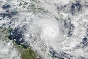
Packing sustained winds of 212 km/hr (132 mph), Tropical Cyclone Inigo is tracking to the west-southwest at 9 km/hr (6 mph). Inigo is expected to intensify over the next 12 hours and then hold intensity through the next 48 hours.

This true-color

Moderate Resolution Imaging Spectroradiometer

(MODIS) image of Inigo was acquired by the

Aqua

satellite on April 2, 2003.

The high-resolution image provided above is 1000 meters per pixel. The MODIS Rapid Response System provides this image at MODIS' maximum spatial resolution of 250 meters.

References & Resources

Image courtesy Jacques Descloitres, MODIS Land Rapid Response Team at NASA GSFC.

You may also be interested in:

Stay up-to-date with the latest content from NASA as we explore the universe and discover more about our home planet.

Tropical Cyclone Narelle Crosses Australia
3 min read

The powerful storm lashed the northern edge of the continent with damaging winds and drenching rain as it made landfall…

Article
Tropical Storm Arthur
2 min read

The first named storm of the 2026 Atlantic hurricane season brought intense rainfall and the threat of flash flooding to…

Article
Snow in the Shadow of the Andes
2 min read

An early autumn storm left higher elevations in southern Argentina with a fresh and fleeting coat of white.

Article