


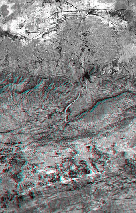
view anaglyph (330 KB)
On January 26, 2001, the Kachchh region in western India suffered themost deadly earthquake in India's history. This stereoscopic view oflandforms northeast of the city of Bhuj depicts geologic structures thatare of interest in the study of the tectonic processes that may have led tothat earthquake. However, preliminary field studies indicate that thesestructures are composed of Mesozoic rocks that are overlain by youngerrocks showing little deformation. Thus these structures may be old, notactively growing, and not directly related to the recent earthquake.
The Haro Hills are on the left and the Kas Hills are on the right. TheHaro Hills are an "anticline," which is an upwardly convex elongatedfold of layered rocks. The anticline is distinctly ringed by an erosionresistant layer of sandstone. The east-west orientation of the anticlinemay relate to the crustal compression that has occurred during India'snorthward movement toward, and collision with, Asia. In contrast, thelargest of the Kas Hills appears to be a tilted (to the south) andfaulted (on the north) block of layered rocks. Also seen here, thecurvilinear ridge trending toward the southwest from the image center isan erosion resistant "dike," which is an igneous intrusion into older"host" rocks along a fault plane or other crack. The dike also appearsto extend northeast from the image center as a dark line having verylittle topography. Its location between the tilted block and a smalleranticline to the north (directly east of the larger anticline) probablyindicates that the dike fills the fault that separates these contrastinggeologic structures. These features are simple examples of how digitalelevation data can stereoscopically enhance satellite imagery to providea direct input to geologic studies.
The stereoscopic effect of this anaglyphwas created by first draping aLandsat satellite image (taken just two weeks after the earthquake) overpreliminary digital elevation data from the Shuttle Radar TopographyMission (SRTM), and then generating two differing perspectives, one foreach eye. When viewed through special glasses, the result is avertically exaggerated view of the Earth's surface in its full threedimensions. Anaglyph glasses cover the left eye with a red filter andcover the right eye with a blue filter.
Elevation data used in this image was acquired by the Shuttle RadarTopography Mission (SRTM) aboard the Space Shuttle Endeavour, launchedon February 11, 2000.
Size: 22.3 x 14.3 kilometers ( 13.8 x 8.9 miles)
Location: 23.4 deg. North lat., 69.8 deg. East lon.
Orientation: North toward the top Image
Data: Landsat Bands 1, 2+4, 3 as blue, green, red, respectively Date
Acquired: February 2000 (SRTM), February 9, 2001 (Landsat)
References & Resources
Image courtesy SRTM and Landsat science teams.
None


