


Today’s Image of the Day is the answer to the March puzzler.
In mid-February each year, satellite images show a hint of yellow spreading through the valleys of Luoping County in southern China. It is the short-lived but lovely bloom of canola flowers.
With the coarse resolution (250 meters per pixel) of the Moderate Resolution Imaging Spectroradiometer (MODIS), the effect is subtle—blooming valleys appear just slightly lighter than the dark green of the forested hills and ridges around them.
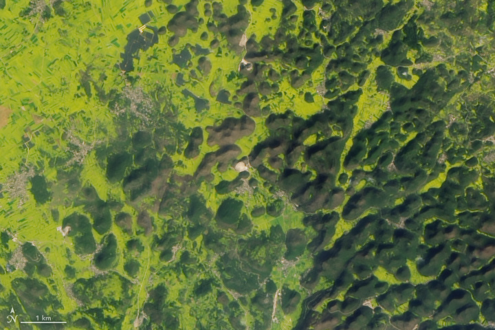
With the finer resolution (30 meters per pixel) of the Operational Land Imager (OLI) on Landsat 8, the effect is much clearer. The boundaries between the expansive yellow fields and the green of the tooth-shaped karst hills is obvious.
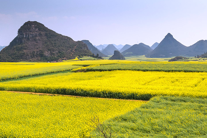
Landsat 8 acquired the image above on February 19, 2017, the time of year when canola flowers are typically in peak bloom. By mid-March, the flowers fade and green reasserts itself over the landscape. The second image—and the photograph below—shows a more detailed view of karst hills against canola fields.
Canola, also called rapeseed, is mainly grown to produce cooking oil and canola meal. Canola oil is the third most-consumed oil in the world, while the meal is used as animal feed for livestock, poultry, and fish. China is one of the world’s top producers and importers of canola products.
The karst hills themselves are notable. They are the product of tectonic forces that pushed up slabs of limestone 200 million years ago, and then erosion that carved the soft rock into rounded, pillar-like hills.
The karst hills and the explosion of yellow flowers have turned Luoping County into a major draw for photographers and tourists. Tens of thousands of people descend on the remote area each spring to hike and partake in flower festivals. Thousands of people even run a marathon through Yunnan’s fields of gold.
The Landsat image below shows canola blooming within narrow valleys in the northern part of Luoping County.

References & Resources
- Amusing Planet Rapeseed Fields in Luoping China. Accessed March 7, 2019.
- Atlas Obscura Canola Flower Fields. Accessed March 7, 2019.
- CNC Aerial view: ocean of rapeseed flowers in Yunnan. Accessed March 7, 2019.
- Country Guide Why China needs canola imports. Accessed March 7, 2019.
- Huadon, G. (2013) South China Karst. Atlas of Remote Sensing for World Heritage: China. (Berlin: Springer)
- GeoTimes (2007) Exploring Karst in Guilin, China. Accessed March 7, 2019.
- U.S. Canola Association Seed, Meal and Oil. Accessed March 7, 2019.
NASA Earth Observatory images by Lauren Dauphin, using Landsat data from the U.S. Geological Survey. Story by Adam Voiland. Ground photograph by Stephane Damour.


