


August 1-12, 2019
Heavy Monsoon Rains Flood South Asia
Several weeks of heavy monsoon rains in August 2019 swamped Burma (Myanmar) and southern and western India, unleashing destructive floods and landslides. Above-average monsoon rainfall caused rivers and streams to overflow their banks, while destabilizing hillsides in several regions.
The annual monsoon in south Asia typically has its greatest impact between July and September. India, for instance, receives roughly 70 percent of its annual rainfall from the monsoon. The rain is critical for replenishing freshwater supplies and for watering crops. But with at least 15 percent of the country prone to floods, the monsoon also leads to several thousand deaths each year.
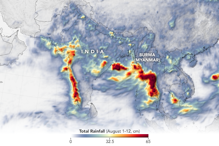
The animation above depicts satellite-based measurements of rainfall from August 1–12, 2019. The darkest reds reflect the highest rainfall amounts, with many places receiving 60 centimeters (24 inches) or more during this period. The image below shows the totals after twelve days. The measurements are a product of the Global Precipitation Measurement (GPM) mission, a partnership between NASA, the Japan Aerospace Exploration Agency, and five other national and international partners.
The rainfall totals are regional, remotely-sensed estimates. Each pixel shows 0.1 degrees of the globe (about 7 miles at the equator), and the data are averaged across each pixel. Individual ground-based measurements within a pixel can be significantly higher or lower than the average. The data come from Integrated Multi-Satellite Retrievals for GPM (IMERG), a product of the GPM science team. IMERG compiles precipitation estimates from several satellites, as well as surface precipitation gauge data, to provide precipitation estimates between 60 degrees North and South latitude.
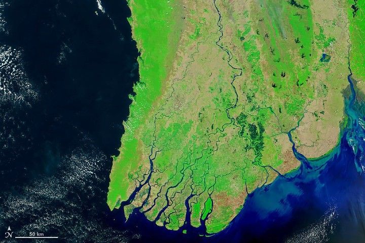
The false-color images at the top of this page reveal flood conditions in Burma (Myanmar) through cloudy skies in one of the few NASA satellite views of that land surface this view. The images were acquired by the Moderate Resolution Imaging Spectroradiometer (MODIS) on NASA’s Terra satellite on April 2 (left) and August 15, 2019 (right). They were composed from a combination of visible and infrared light (MODIS bands 7-2-1) to distinguish water on the land surface (blue and navy) from clouds (white and teal).
In Burma (Myanmar), a landslide took the lives of at least 60 people on August 9. The UN Office for the Coordination of Humanitarian Affairs reported that more than 80,000 people have been moved to emergency shelters amid widespread flooding.
In India, the worst of the flooding hit the western and southern states of Kerala, Karnataka, Maharashtra, and Gujarat. Several hundred people have died, and more than a million have been displaced. Flood waters have damaged roads and rail lines in several areas, and destroyed thousands of hectares of summer crops.
The India Meteorological Department reported to media that the country received 45 percent more rainfall than average for the week of August 7–14. However, overall rainfall for the 2019 monsoon (starting June 1) is only 1 percent above the 50-year average.
References & Resources
- Al Jazeera (2019, August 14) India floods, landslides kill more than 270. Accessed August 15, 2019.
- Al Jazeera (2019, August 14) Daeth toll in Myanmar landlside rises as rescue efforts continue. Accessed August 15, 2019.
- BBC (2019, August 13) Myanmar landslide death toll rises to 59. Accessed August 15, 2019.
- India Today (2019, August 14) Monsoon Updates: Congress demands complete loan waiver for Maharashtra flood-hit farmers. Accessed August 15, 2019.
- The Guardian (2019, August 14) India issues new flood alert as monsoon death toll reaches 244. Accessed August 15, 2019.
- Thomson Reuters (2019, August 14) India gets above-average monsoon rains for third straight weekâweather office. Accessed August 15, 2019.
- Times of India (2019, August 14) Why floods continue to cause so much damage in India. Accessed August 15, 2019.
- Voice of America (2019, August 12) Tens of Thousands Flee Homes in Flood-Hit Myanmar as Landslide Toll Hits 59. Accessed August 15, 2019.
NASA Earth Observatory image and video by Joshua Stevens, using IMERG data from the Global Precipitation Mission (GPM) at NASA/GSFC, and MODIS data from NASA EOSDIS/LANCE and GIBS/Worldview. Story by Michael Carlowicz.


