


A low-pressure system called a “Kona low” developed northwest of Hawai’i in the first week of December 2021, dropping snow on the peaks of Mauna Kea and Mauna Loa. The storm also brought high winds, intense rainfall, and flash flooding, along with reports of landslides, downed trees, and power outages. Some roads and schools were closed, and Hawai’i Governor David Ige declared a state of emergency.
On Oahu, the Honolulu airport received 7.92 inches (20.12 centimeters) of rain on December 6, breaking the single-day record for December, according to the National Weather Service (NWS). It was also the second-highest amount of rain ever received in Honolulu in a single day. Maui recorded 12.86 inches of rain (32.65 centimeters), although NWS estimated that up to 20 inches (51 centimeters) fell on south-facing mountain slopes.
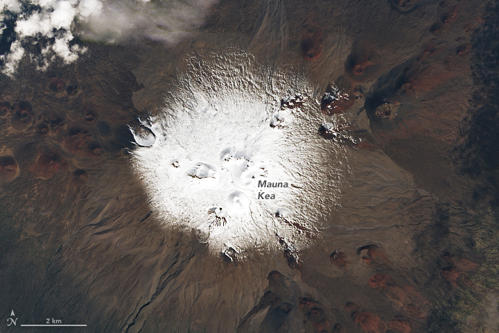
On the “Big Island” of Hawai’i, the storm produced 14.26 inches (36.22 centimeters) of rain and prompted a blizzard warning for high winds and snowfall atop Mauna Kea and Mauna Loa. The peaks rise to elevations of 13,803 feet (4,207 meters) and 13,679 feet (4,169 meters), respectively. The natural-color images on this page, acquired on December 7 by the Operational Land Imager (OLI) on Landsat 8, show the snow-capped peaks. Webcams maintained on Mauna Kea by the Canada–France–Hawai’i Telescope and on Mauna Loa by the U.S. Geological Survey showed significant accumulations on the peaks.
While blizzard conditions are rare in Hawai’i, snow is not uncommon on the two tallest volcanoes in the island chain. Snow is often associated with a Kona low, which occurs when winds that typically blow out of the northeast shift and begin to blow from the southwest, over the leeward or “Kona” side of the islands. As the air, laden with moisture from the tropical Pacific, is forced up by the mountainous topography, the moisture precipitates as heavy rain and snow. Kona storms are common between October and April.
References & Resources
- Hawaiâi News Now (2021, December 7) Threat of rain is winding down, Kauai remains under a Flood Watch but likely wonât receive substantial rain with the kona low moving away from the state. Accessed December 8, 2021.
- Honolulu Star Advertiser (2021, December 6) Oahu, Kauai County remain under flood watch as kona low lingers. Accessed December 8, 2021.
- NASA Earth Observatory (2021, February 9) Trading Surfboards for Snowboards.
- NASA Earth Observatory (2007, December 7) Kona Low over Hawaii.
- The Washington Post (2021, December 8) Hawaii drying out after historic December deluge, flooding. Accessed December 8, 2021.
- The Washington Post (2021, December 7) Hawaii governor declares state of emergency as heavy rains bring âdanger of a disasterâ. Accessed December 8, 2021.
- The Washington Post (2021, December 3) Blizzard predicted to plaster Hawaiiâs high peaks amid major storm. Accessed December 8, 2021.
NASA Earth Observatory images by Lauren Dauphin, using Landsat data from the U.S. Geological Survey . Story by Sara E. Pratt .


