April 13, 2014-March 31, 2021
A Renewable Future for Fukushima
In 2011, an earthquake and tsunami damaged nuclear reactors and released radioactive material from the Fukushima Daiichi Nuclear Power Plant in northeastern Japan. More than a decade later, the area around the damaged power plant has become a hub of renewable energy production.
Many fields no longer suitable for farming now gleam with rows of solar panels due to a multibillion-yen investment in renewable energy. Government and industry financiers are pursuing plans to develop 11 solar farms and 10 wind farms on abandoned or contaminated land around Fukushima, according to news reports.
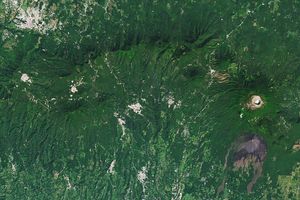
The Operational Land Imager (OLI) on Landsat 8 acquired this natural-color image of the region on March 31, 2021. For comparison, the other image shows the same area in April 2014. Some of the most prominent solar installations are located near the towns of Futaba (above) and Tomioka (below).
In 2014, Fukushima prefecture announced a goal of having all of its energy come from renewable sources by 2040. Local leaders have made considerable strides, with 43 percent of energy coming from renewable sources by 2020, up from 24 percent in 2011.
Prior to the accident at Fukushima, nuclear power provided about one quarter of Japan’s electricity. This share plummeted to less than 1 percent after the accident. The rapid expansion of renewable energy production has helped compensate for the change, but the share of natural gas and coal has increased significantly as well, according to data from the U.S. Energy Information Administration. In recent years, the use of nuclear power in Japan has also rebounded, accounting for 7 percent of electricity generation in 2019.
Â
References & Resources
- Fukushima Prefectural Government (2014) Fukushima Revitalization Station. Accessed April 13, 2022.
- The Mainichi (2019, May 25) Solar spread. Accessed April 13, 2022.
- NASA Earth Observatory (2011) 2011 Great Tohoku Earthquake.
- France24 (2022, March 9) Fukushima region forges renewable future after nuclear disaster. Accessed April 13, 2022.
- National Geographic (2021, March 10) Fukushimaâs tragic legacyâradioactive soil, ongoing leaks, and unanswered questions. Accessed April 13, 2022.
- Nikkei Asia (2019, November 10) Fukushima to be reborn as $2.7bn wind and solar power hub. Accessed April 13, 2022.
- Nikkei Asia (2018, March 11) Flight over Fukushima reveals cleanup gaps. Accessed April 13, 2022.
- The Verge (2019, November 12) Fukushima reinvents itself with a $2.7 billion bet on renewables. Accessed April 13, 2022.
- U.S. Energy Information Administration (2020, November 2) Japan. Accessed April 13, 2022.
- World Nuclear Association (2021) Fukushima Daiichi Accident. Accessed April 13, 2022.
- YaleEnvironment360 (2019, November 11) Fukushima to be Transformed into Renewable Energy Hub. Accessed April 13, 2022.
NASA Earth Observatory images by Lauren Dauphin, using Landsat data from the U.S. Geological Survey . Story by Adam Voiland .