


Santa Claus better bundle and buckle up. Forecasters are warning that a blast of Arctic air will bring dangerously cold conditions to parts of Canada and the central and eastern U.S. in the days before Christmas 2022.
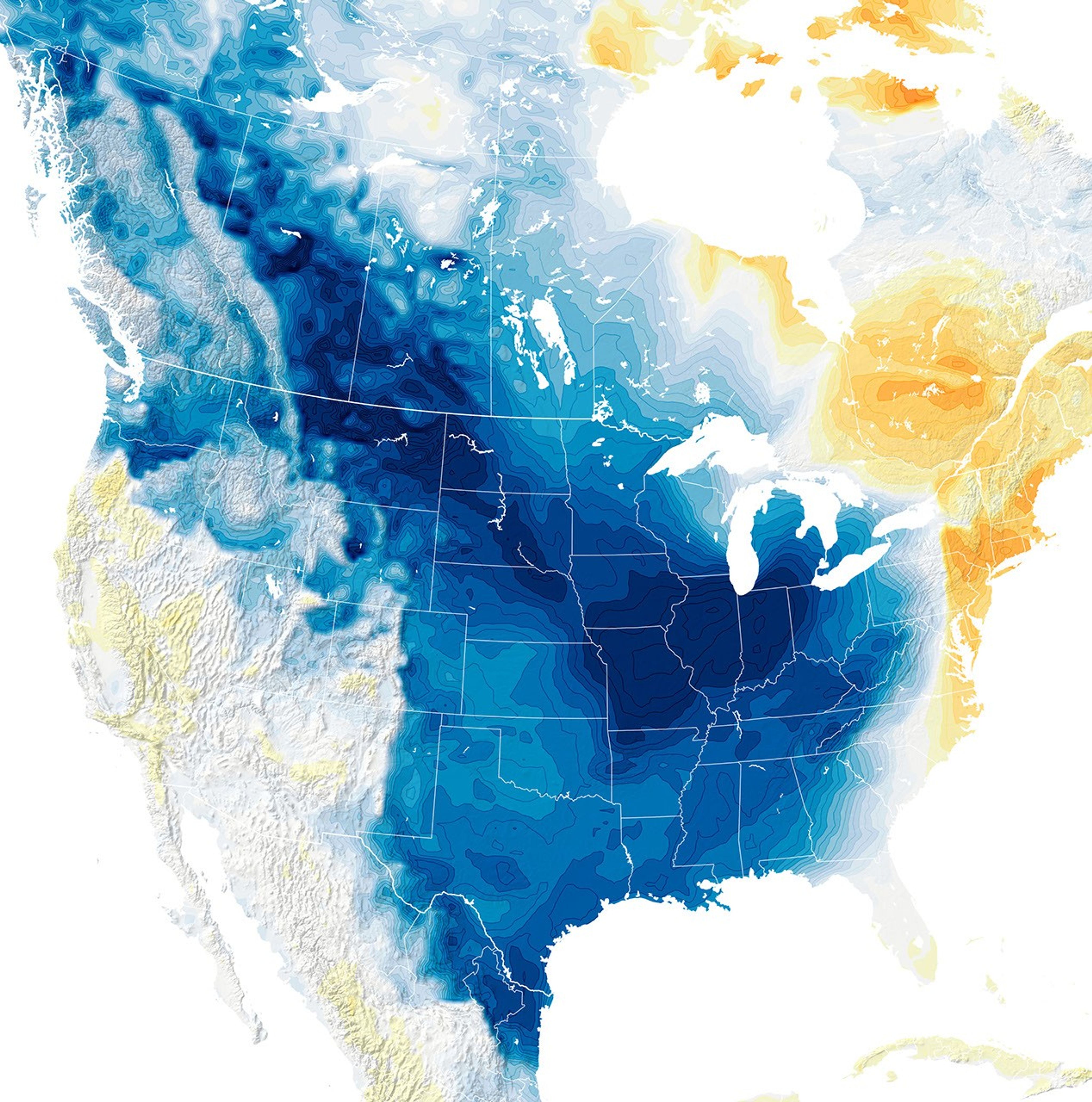
The map above shows the surface air temperature anomalies forecasted for December 23, 2022. It was produced by combining satellite observations with temperatures predicted by a version of the Goddard Earth Observing System (GEOS) global model, which uses mathematical equations to represent physical processes in the atmosphere. The darkest blue areas indicate where surface temperatures are expected to drop at least 25 degrees below average as the front arrives.
“The initial surge of frigid air will plunge rapidly south from Canada into Texas on December 22 and trigger an impressive winter system along its boundary, with much warmer and moister air flowing northward from the Gulf of Mexico,” explained Gary Partyka, an atmospheric scientist with the Global Modeling and Assimilation Office at NASA’s Goddard Space Flight Center. “This system will produce blizzard conditions for large parts of the Midwest, Ohio Valley, and Great Lakes. The extremely cold airmass will then progress toward the eastern third of the U.S.” The winter storm will bring fierce winds, whiteout conditions, and several inches of snow.
Accounting for wind chill could push temperatures to -7°F in Dallas, -14°F in Memphis, and -32°F in Kansas City, and -45°F in Sioux Falls, The Washington Post reported. The National Weather Service in Cheyenne warned that temperatures could fall to as low as -70°F in eastern Wyoming. “The wind chill forecast features some of the most extreme values you will ever see,” the Cheyenne office cautioned. “Check on the elderly and vulnerable, protect pets, shelter livestock, cover exposed skin!”
While official forecasts from the National Weather Service are based on weather models maintained by the National Weather Service, the weather forecasting capabilities of the GEOS model at Goddard are mostly used for research purposes and to support specific NASA satellite missions and field campaigns. In 2022, the model was used to support near real-time atmospheric weather and chemistry forecasts for 10 NASA field campaigns—the largest number since 2017.
Among them were Blue Carbon Prototype Products for Mangrove Methane and Carbon Dioxide Fluxes (Blueflux), Dynamics and Chemistry Of The Summer Stratosphere (DCOTSS), and Low-Earth Orbit Flight Test of an Inflatable Decelerator (LOFTID)—missions to study carbon flux from mangrove swamps in Florida, the chemistry of the summer stratosphere, and a new type of inflatable heat shield.
References & Resources
- AccuWeather (2022, December 17) Widespread outbreak of Arctic air to send temperatures plummeting across US. Accessed December 21, 2022.
- NASA GMAO (2022) GMAO Mission. Accessed December 21, 2022.
- NASA Center for Climate Simulation (2022, September 29) GMAO and NCCS Provide Forecasts for 10 NASA Field Campaigns. Accessed December 21, 2022.
- National Weather Service Weather Prediction Center via Twitter (2022, December 20) Considerable travel impacts behind an Arctic cold front this week. Accessed December 21, 2022.
- National Weather Service Weather Prediction Center (2022, December 21) Winter Weather Forecast Discussion. Accessed December 21, 2022.
- The Washington Post (2022, December 20) Fierce ‘bomb cyclone’ to disrupt holiday travel, unleash Arctic outbreak. Accessed December 21, 2022.
- Yale Climate Connections (2022) The weather nightmare before Christmas. Accessed December 21, 2022.
NASA Earth Observatory image by Joshua Stevens , using GEOS-5 data from the Global Modeling and Assimilation Office at NASA GSFC. Story by Adam Voiland .