


December 17, 2022-January 9, 2023
Flooding Along Australia’s Fitzroy River
Starting on December 30, 2022, remnants of Tropical Cyclone Ellie brought days of torrential rain and wind to northern Western Australia. The deluge caused the Fitzroy River to swell to record-high levels, inundating floodplains and isolating several riverside communities.
The flooding is visible in this false-color image (right), acquired on January 9, 2023, with the Moderate Resolution Imaging Spectroradiometer (MODIS) on NASA’s Aqua satellite. Water appears light to dark blue; vegetation is green and bare land is brown. The left image, acquired with Aqua MODIS on December 17, 2022, shows the same area prior to the storm.
Flooding is common along rivers of the Kimberly region in Western Australia. But the amount of water delivered by the ex-tropical cyclone was exceptional. From December 30, 2022, through the first week of January 2023, rainfall totals across the region ranged from 200 to 500 millimeters (7.9 to 19.7 inches).
As a result, the Fitzroy River’s flow rate reached about 60,000 cubic meters per second—well above the 23,000 cubic meters per second usually seen during floods on this river, and one of the highest flow rates ever observed in any Australian river. Australia’s Bureau of Meteorology reported that the river’s water levels near the town of Fitzroy Crossing peaked at a record-high 15.81 meters on January 4. That’s almost two meters higher than the previous record reached during flooding in 2002.
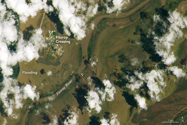
The floodwater left many roads and bridges impassable, isolating Fitzroy Crossing, Derby, Broome, and many of the region’s remote indigenous communities. Floodwaters around Fitzroy Crossing are visible in this natural-color image, acquired on January 7, 2023, with the Operational Land Imager (OLI) on Landsat 8.
Tropical Cyclone Ellie first hit Australia’s Northern Territory as a category-1 storm on December 23, 2022. It then weakened into a tropical low before moving into Western Australia on December 30. By January 7, 2023, the former tropical cyclone had moved back into the Northern Territory and further weakened as it moved toward Queensland.
The recent flooding in Western Australia follows several severe flooding events that have occurred in eastern Australia during three consecutive years of La Niña conditions. La Niña usually brings wetter-than-average conditions to the country. 2022 was Australia’s ninth-wettest year on record.
References & Resources
- ABC News (2023, January 9) Former tropical cyclone Ellie returns to the NT, bringing heavy rainfall to the territory’s south-west. Accessed January 9, 2023.
- ABC News (2023, January 9) Prime Minister Anthony Albanese announces ‘significant’ financial flood aid for Fitzroy Crossing. Accessed January 9, 2023.
- ABC News (2023, January 9) WA floods prompt Kimberley visit from Anthony Albanese and Mark McGowan amid devastation. Accessed January 9, 2023.
- Australian Government Bureau of Meteorology (2023, January 6) WA floods prompt Kimberley visit from Anthony Albanese and Mark McGowan amid devastation. Accessed January 9, 2023.
- Australian Government Bureau of Meteorology (2023, January 5) Flooding impacts continue in Western Australia as Ex-Tropical Cyclone Ellie moves to the southern Kimberley region. Accessed January 9, 2023.
- BBC News (2023, January 9) Australia flood crisis: ‘Once in a century’. Accessed January 9, 2023.
- Government of Western Australia, Department of Water (2008) Water Notes. Accessed January 9, 2023.
- Prime Minister of Australia (2023, January 9) Disaster Assistance for Kimberley Shire’s Affected by Record-Breaking Flooding. Accessed January 9, 2023.
- Reuters (2023, January 9) Australia PM pledges aid on visit to flood-ravaged northwest. Accessed January 9, 2023.
- The Sydney Morning Herald (2023, January 4) Flooded Fitzroy River flow equal to 20 years of Perth’s water use. Accessed January 9, 2023.
NASA Earth Observatory images by Lauren Dauphin, using MODIS data from NASA EOSDIS LANCE and GIBS/Worldview and Landsat data from the U.S. Geological Survey . Story by Kathryn Hansen .


