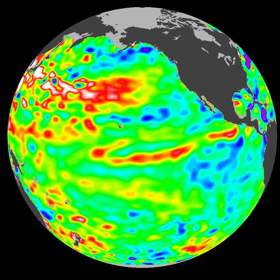
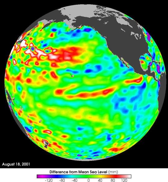
These data, taken during a 10-day collection cycle ending August 18 by the TOPEX-Poseidon mission,2001, show that above-normal sea-surface heights and warmer oceantemperatures (indicated by the red and white areas) still blanket thefar-western tropical Pacific and much of the north (and south)mid-Pacific. Red areas are about 10 centimeters (4 inches) above normal;white areas show the sea-surface height is between 14 and 32 centimeters(6 to 13 inches) above normal.
This build-up of heat dominating the Northern and Western Pacific wasfirst noted by Topex/Poseidon oceanographers almost three years ago andhas outlasted the El Niño and La Niña events of the past few years. (Seehttp://www.jpl.nasa.gov/elnino/990127.html.) This warmth contrasts withthe Bering Sea, Gulf of Alaska and Eastern tropical Pacific wherelower-than-normal sea levels and cool ocean temperatures continue(indicated by blue areas). The blue areas are between 5 and 13centimeters (2 and 5 inches) below normal, whereas the purple areasrange from 14 to18 centimeters (6 to 7 inches) below normal. Across thetropics, the equatorial ocean remains calm with no indication of any ElNiño developing.
Looking at the entire Pacific basin, the Pacific DecadalOscillation’s warm horseshoe in the North and West Pacific and coolwedge pattern in the Eastern Tropical Pacific still dominates thissea-level height image. Most recent National Oceanic and AtmosphericAdministration sea-surface temperature data also clearly illustrate thepersistence of this basin-wide pattern. They are available athttp://psbsgi1.nesdis.noaa.gov:8080/PSB/EPS/SST/climo.html.
References & Resources
Image Courtesy Topex Poseidon Team, NASA JET Propulsion Lab and the Centre National d’Etudes Spatiales