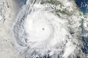
















Tropical Cyclone Dora was spinning down on the morning of February 5, 2007, when the Moderate Resolution Imaging Spectroradiometer (MODIS) on NASA’s Terra satellite captured this image. At the time, Dora had winds of 120 kilometers per hour (75 miles per hour or 65 knots) with gusts to 148 km/h (92 mph, 80 knots), not an extremely powerful storm as far as cyclones go. Dora formed on January 28 over the mid-Indian Ocean, and developed into a strong cyclone with winds of 213 km/hr (132 mph, 115 knots), equivalent to a Category four hurricane, by February 3. Though the storm had weakened from its peak strength when MODIS captured this photo-like image, Dora retained the tightly wound, circular shape of a well-formed cyclone. On February 6, Dora was expected to continue to degrade as it moved south over cooler waters. It was not forecast to threaten land.
References & Resources
NASA image created by Jesse Allen, using data provided courtesy of the MODIS Rapid Response team.