
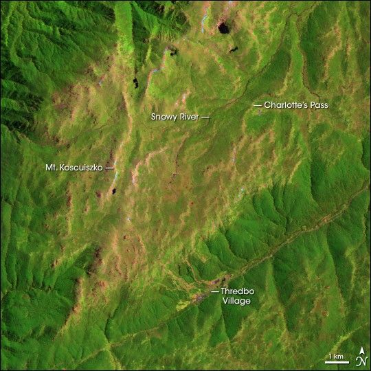
The 2,228-meter-tall (7,310-foot) Mt. Kosciuszko lies at the southern end of Australia’s Snowy Mountains,which define the Kosciuszko National Park. Though it is the tallest mountain on the continent, Kosciuszko is veryeasy to climb. In summer, it is a scramble up the slope from the Thredbo Village (or you can take thechairlift!) to the plateau, and a gentle 6-km (4-mile) walk to the mountain. The sensitive alpinegrasses are protectedfrom the foot traffic by a steel grate, making the walk all the less challenging (though highlydiscouraged by the Park Service when thunderstorms are threatening!). The gratework ends at a carpassable road (though no traffic is permitted past Charlotte’s Pass) on which it is another 10-minutestroll to the peak. In summer, it is a pleasant and cool hike of an hour or two, while in winter theelevated plains are covered in deep snow, but still quite passable on skis or snowshoes.Hardly Everest! In fact, “peak baggers” have suggested that theSeven Summits should instead include New Zealand’s Mt. Cook or Indonesia’s Puncak Jaya (also knownas Carstenz Pyramid). However, Oceania is not a continent, so Kosciuszko is the true highest peak onthe Australian continent.
The mountain’s name (known as “Kozzy” to Australians) comes from the fertileimagination of the first European explorer to reach the Snowy Mountains, Paul Strzlecki. On arrivingin the Snowy Mountains in 1840, he thought the mountain’s gentle slopes were suggestive of the tomb ofthe Polish general, Thaddeus Kosciuszko, who assisted the Americans in the 1770s in their war against the British, and in the 1790s with the Polish again Russia. However, for many decades the mountain’s name was mispelled “Kosciusko” by Australians and was only corrected in the 1990s duringtrade negotiations with Poland. Aboriginal Australians had been visiting the Snowy Mountains andneighboring Bogong High Plains during the summer months for thousands of years prior to Strzlecki’svisit in hunt of the nutritious Bogong moths.
Mt. Kosciuszko is part of the Great Dividing Range, a long chain of mountains running along theAustralian east coast which seperate the arid inland from the more fertile and densely-populatedcoastal regions. The Snowy Mountains are the centerpiece of a huge engineering program, in which a series ofdams and tunnels were constructed during the 1950s to draw on the reliable water supply from snowmeltinto the inland regions for irrigation. By bringing water falling on the eastern side of theSnowys into the drainage basin on the west, Australia opened up huge areas to agriculture that hadbeen previously too arid to farm. But even after the water diversion scheme was completed, theregion remained sparsely populated and the Great Divide still seperates much of the populationfrom the interior of the continent. The range itself is ancient and, indeed, may be one of the oldestmountain ranges in the world. Its relatively low altitude and gentle slopes reflect hundreds of millions of years of erosion.
The land to the immediate north and east of Kosciuszko seen in the image above is moderately flat, elevated land withreliable annual snowpack in winter from which the Snowy River receives much of its flow. Unlikemost Australian rivers, water flows through the Snowy all year long rather than drying up in summer.In winter, Thredbo becomes a popular ski resort—some of the ski runs are visible here as pinkareas where trees are cleared from the runs down the slope back towards the village. In thehigh-resolution image which shows more of the region around the National Park,the reservoirs of the Snowy Mountain Scheme are quite evident. The north-south trending greenery isthe Kosciuszko National Park which extends for a hundred kilometers or so north of the mountain, as wellas the neighboring Begong High Plains to the south. The large arc-shaped lake is the Hume Reservioron the Murray River.
This image was acquired by Landsat 5’s Thematic Mapper (TM) sensor on February 8, 1991. This is afalse-color image made using infrared, near-infrared,and red wavelengths (TM bands 5, 4, and 3). In this scheme, bare land without vegetation ispink, green areas show healthy vegetation and forests, and water appears dark blue.
[Editor’s Note: This is one in an ongoing series of Landsat scenes of the Seven Summits. Previouspeaks include Asia’sMt. Everest,North America’sDenali/Mt. McKinley,South America’sCerro Aconcagua,and Africa’sKilimanjaro.]
References & Resources
Image courtesy the University of Maryland Global Land Cover Facility