


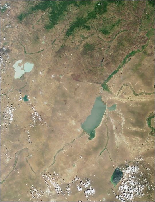
Here’s another chance to play geographical detective! This Multi-angleImaging SpectroRadiometer (MISR) image covers an area of about 317 kilometers x412 kilometers, and was captured by the instrument’s vertical-viewing (nadir)camera on July 4, 2001. Use any reference materials you like and answer thefollowing three questions:
- Near the left-hand edge, above image center, are two light-blue lakesseparated by a narrow strip of land. Three of the following four statementsabout them are true. Which one is false?
- The lakes are in a depression formed by tectonic and volcanic activity.
- Several rare and endangered bird species breed here.
- The dominant species of fish is the weatherfish, Misgurnus fossilis.
- Water levels can vary considerably, causing changes to the size of exposed islands.
- To the right of image center is a large lake. About 30 kilometers northwestof the northern tip of this lake is a border city, which from 1913 to 1949 had adifferent name than the one it goes by today. Three of the following fourstatements about the city are true. Which one is false?
- Coal mining and food processing are important to the local economy.
- Transshipment facilities for handling crude oil are planned, but have not yet been constructed.
- Mammoth fossils have been discovered here.
- Railway passengers can cross the border into this city on the #20 train.
- In the lower right-hand quadrant of the image is a blue-green lake partiallyobscured by some cumulus clouds. This lake is part of a nation whose capitalcity contains a landmark square named for a national hero. A statue in thesquare portrays this individual (choose one):
- At the helm of a ship
- Seated on a throne
- Standing in the company of another person
- On horseback
Quiz Rules
E-mail your answers, name (initials are acceptable if you prefer), and yourhometown by Tuesday, April 9, 2002 to suggestions@mail-misr.jpl.nasa.gov . Thefirst 3 people on this list who are not affiliated with NASA, JPL, or MISR andwho did not win a prize in the last quiz will be sent a print of the image.Answers will be published on the MISR web site (http://www-misr.jpl.nasa.gov/gallery/galhistory/2002_apr_03.html)in conjunction with the next weekly image release. The names and home towns ofrespondents who answer all questions correctly by the deadline will also bepublished in the order responses were received.
A new “Where on Earth...?” mystery appears as the MISR “image of the week”approximately once per month. A new image of the week is released everyWednesday at noon Pacific time on the MISR home page. The image also appears on the Atmospheric Sciences Data Centerhome page, though usually with a several-hourdelay.
References & Resources
Image courtesy NASA/GSFC/LaRC/JPL, MISR Team


