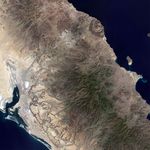

The arid climate of Baja California limits the amount of vegetation covering the ground and allows the dramatic volcanic features of the landscape to stand out in this natural-color image from the Landsat satellite on October 5, 2000. The landscape is a patchwork of lava flows and the hardened remains of pyroclastic flows—hot clouds of volcanic ash, dust, and rock fragments that race down the slopes of a volcano like an avalanche.
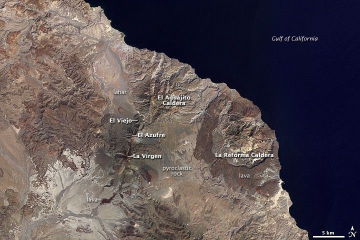
On the eastern coast of the peninsula, facing the Gulf of California, is the massive La Reforma Caldera. The outer rim of the caldera is defined by dark-colored rocks made out of very fluid lava. A dome of rock in the center of the caldera is a resurgent dome. A resurgent dome is formed as the floor of the caldera is heaved upward by the movement of magma below ground. The lavas surrounding the caldera date to about 1 million years ago.
West of La Reforma is a line of three connected volcanoes. La Vírgen, in the southwest, El Azufre in the center, and El Viejo in the northeast. The volcanoes get larger and younger from northeast to southwest. As recently as 6,500 years ago, La Vírgen experienced a plinian eruption—a huge, explosive event that produces an enormous column of volcanic rock fragments and gas that reaches into the stratosphere. The eruption produced a column that reached at least 18 kilometers into the air and deposited ash and rock fragments over 500 square kilometers. In later stages of the eruption, pyroclastic flows (pinkish rocks) and lahars (mudflows, grayish rocks) from El Azufre Volcano paved the plain to the north all the way to the Gulf of California.
North-northeast of Las Tres Vírgenes is El Aguajito Caldera, where pyroclastic rocks and lava date to between 500,000-800,000 years old. The rim of caldera is not continuously exposed at the surface, but the rocks have a subtle circular arrangement. Like La Reforma, the northern rim of El Aguajito follows the coastline. The flat-looking rock formations, carved by arroyos, are lava domes, hardened mounds of slow-moving, sticky lava. The topography in the southern part of the caldera is more rugged and irregular. The rocks are a combination of pyroclastic deposits and a slightly more fluid lava than what erupted near the coast.
References & Resources
- Capra, L., Macias, J.L., Espindola, J.M., and Sieb, C. (1998). Holocene plinian eruption of La Virgen volcano, Baja California, Mexico. Journal of Volcanology and Geothermal Research 80, 239ââ¬â266.
- Hausback, B.P., Stock, J.M., Dmochowski, J.E., Farrar, C.D., Fowler, S.J.,Sutter, K., Verke, P., and Winant, C.D. (2000). To be or not to be a caldera—La Reforma caldera, Baja California Sur, Mexico.Geological Society of America, Abstracts with Programs 32(7), A502.
- Garduño-Monroy, V.H., Vargas-Ledezma, H., Campos-Enriquez, J.O. (1993). Preliminary geologic studies of Sierra El Aguajito, Baja California, Mexico: a resurgent-type caldera. Journal of Volcanology and Geothermal Research 59, 47-58.
NASA image created by Jesse Allen, using Landsat data provided by the United States Geological Survey. Caption by Rebecca Lindsey.