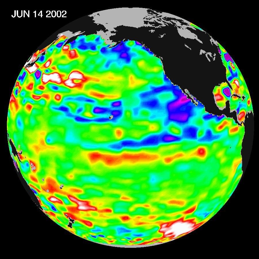
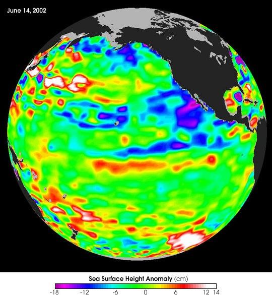
The Pacific Ocean doesn't show signs of anything that looks like the whopper ElNiño of 1997-1998, according to the latest information from the U.S.-Frenchocean-observing satellite Topex/Poseidon. The data do show that themid-equatorial Pacific Ocean has slowly warmed by about 1 degree Celsius (1.8degrees Fahrenheit) above normal in the past few months. However, the Pacificcontinues to be dominated by the larger-than-El Niño/La Niña pattern called thePacific Decadal Oscillation, which may discourage El Niño development.
"Except for some recent mid-Pacific warming, June 2002 looks very much like June2001," said oceanographer Dr. William Patzert of NASA's Jet PropulsionLaboratory, Pasadena, Calif. "We're still in an El Niño holding pattern." (Seehttp://sealevel.jpl.nasa.gov/elNiño/20010621.html for the June 2001 image.)
The ocean warming in the past month can be explained by a relaxation in theequatorial trade winds observed by NASA's Quick Scatterometer (QuikScat)satellite, which measures ocean wind speed and direction. These winds usuallyblow from the Americas towards Asia, helping push warm water eastward. "For thefirst two weeks of June, these winds were unusually weak," said Dr. Timothy Liu,QuikScat project scientist. "But by last week, they had returned to normal. Ifthe weakening continued or intensified, we could have been expecting an El Niñoto develop by early fall." (See http://airsea-www.jpl.nasa.gov/ENSO.)
For the past few winters the weather- and moisture-delivering jet stream hasbeen steered north by the Pacific Decadal Oscillation and other planetarypatterns, resulting in a warm winter all across the United States and very dryconditions on the East and West coasts. A large enough El Niño might providesome relief for the drought-plagued west, southwest and southeast U.S., but it'swishful thinking so far," Patzert added.
The Topex/Poseidon data were taken during a 10-day collection cycle ending June14, 2002. They show that there hasn't been any fundamental change in theocean's large-scale patterns for the past three years. The near-equatorial oceanhas been very quiet, although sea levels and sea-surface temperatures are nearnormal or slightly warmer throughout the far western and central tropicalPacific. Red areas are about 10 centimeters (4 inches) above normal; whiteareas show the sea-surface height is between 14 and 32 centimeters (6 to 13inches) above normal. This warmth contrasts with the Bering Sea, Gulf of Alaskaand U.S. West Coast, where lower-than-normal sea-surface levels (blue areas) andcool ocean temperatures continue. The blue areas are between 5 and 13centimeters (2 and 5 inches) below normal, and the purple areas range from 14 to18 centimeters (6 to 7 inches) below normal.
For more information, read: As Summer Starts, Next El Niño Is Slow to Grow.
References & Resources
Image courtesy NASA/JPL Topex and Jason Team