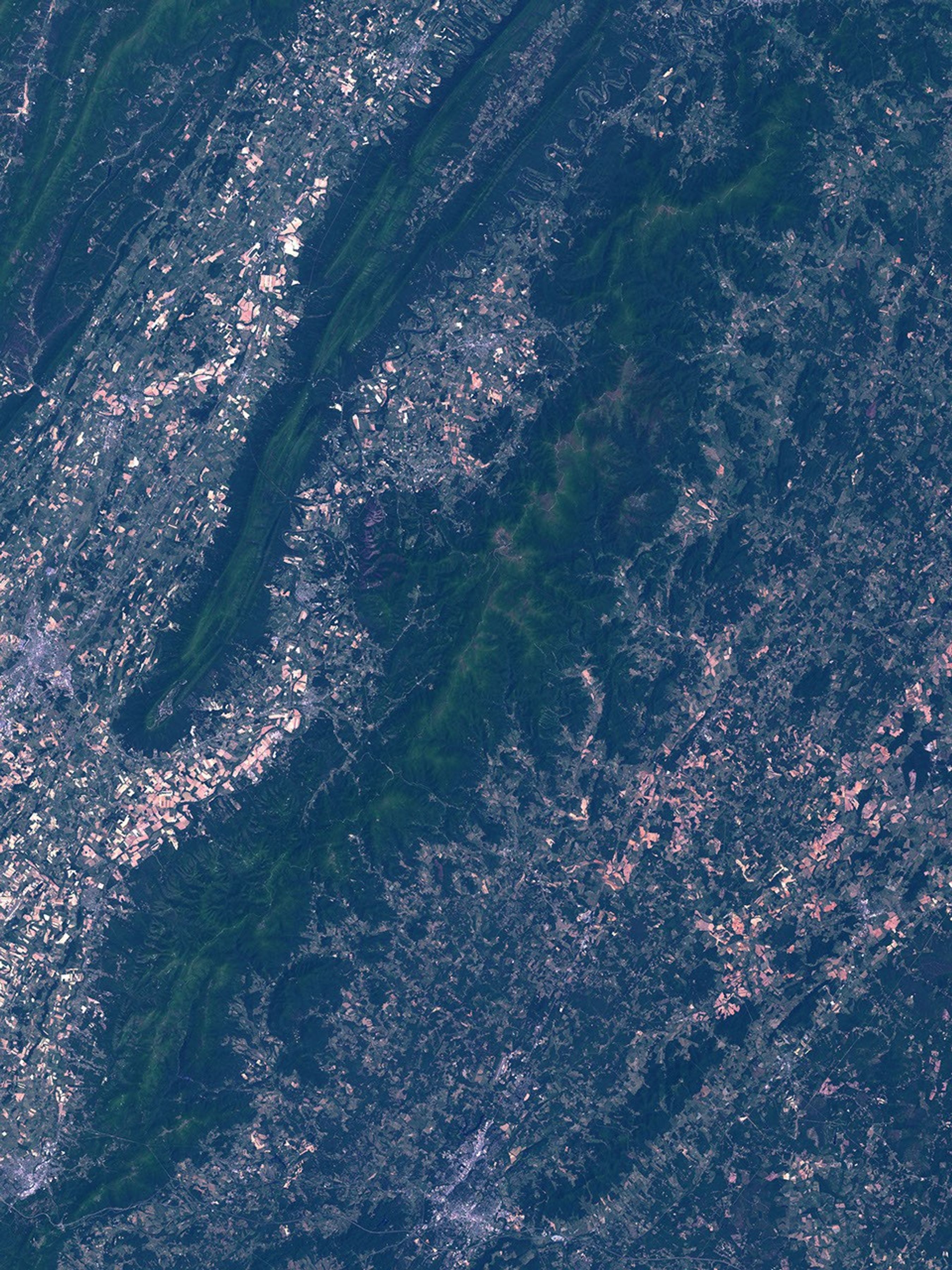
The Shenandoah National Park stretches through the Blue Ridge Mountains in northernVirginia. The area was first set aside as a National Park in 1935 after many years of effort. One aim was to create a substantial national park similarto those previously created in the West, but located nearer to the population centersof the U.S. East Coast. The park idea was developed gradually before 1935, with some land acquisitions for a 100-foot right-of-way along the ridgeline for the creation of Skyline Drive. The scenic highway paralleled and displaced in palces the then-recentAppalachian Trail, a 2144 mile long "super trail" running fromGeorgia to Maine that was created in 1926. Some large areas were made available from willing largelandowners, including President Herbert Hoover whose fishing camp at Rapidan Riverwas included in the proposed park area, but other land owners fought park land condemnation. With the coming of the Great Depression,the Civilian Conservation Corp (CCC) was established and eleven construction camps were established in the park to help create the 105-mile long Skyline Drive through the center of the park.
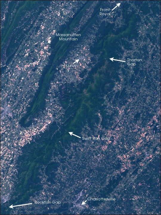
The park now encompasses about 200,000 acres of land, divided into three sections.The northern part runs from Front Royal to Thornton Gap where a major highwaycuts through the ridge to connect the town of Luray with the towns east of the park.The central section spans from Thornton Gap down to Swift Run Gap where anotherroad crosses through the park. Finally the southern section runs toRockfish Gap where the Interstate Highway 66 runs out of Charlottesville and into thehills of West Virginia. South of Rockfish Gap, Skyline Drive meets the Blue RidgeParkway, a road that continues along the ridgeline of this first range of theAppalachian Mountains. Beyond the park’s southern boundary, the land is nolonger consistently public (save for the right-of-way corridors for the AppalachianNational Scenic Trail and the Blue Ridge Parkway) until reaching the Smoky Mountain National Park, which straddlesthe border of North Carolina and Tennesse.
The land in the park is of mixed type, reflecting its history and incorporationinto the park. Roughly forty percent is maintained as wilderness areas with noroad access or facilities; these are areas designated in the Wilderness Act asplaces "retaining its primeval character". Visitors are required topractice Leave-No-Trace ethics, and while camping and hiking are permitted in Wildernessareaa, they are subject to limits to minimize the impact of human presence.
All parts of the park maintain some archaeological remains from overtwo hundred years of European settlement in the park area prior to itsnational park declaration. This includes the foundations of abandoned homes ofsome mountain settlers who were forced to relocate when the park was created.In some places, hikers can stroll from forest into an abandoned apple orchardand know they are treading in former farmland. The area was also used for someten thousand years prior as hunting and fishing grounds with some settlementsby native American populations, and traces of their presence can still be foundin the park as well.
This satellite image of the park reflects this heritage. The park is a skinny long shape running roughlynortheast to southwest from Front Royal to Waynesboro at Rockfish Gap (just offthe edge of this image) roughly centered on the main ridgeline on which SkylineDrive runs. It is much wider than the mere 100-foot right-of-way, but retains the shape defined somewhat by the route of Skyline Drive.Numerous scenic-view turnoff spots on the road, built by the CCC, look down on the Shenandoah Valley to the west and across to Massanutten Mountain, or else eastward towards Washington, D.C. and Richmond, Virginia.It is said that in the early years of the park, on a clear day it was possibleto see the Washington Monument some one hundred or so miles away. In modern times,atmospheric smog and haze have robbed these views of some of their majestic breadth.Stands of trees in the park remain from when boreal forests retreated southwardalong the Appalachian ridgeline during the last major ice age, and now aregradually moving northward with global warming. Thus there are stands oftrees more usually associated with southern Canada, such as stately hemlocks and balsam firs.The park appears as a deep rich green of forestcontrasting with the lighter farmland in the valleys on either side, and thegrey concrete of roads and city buildings. Much of the farmland still appearsfallow in this late spring image as summer crops have not yet fully grown in.
This image was acquired byLandsat 7'sEnhanced Thematic Mapper plus (ETM+) sensor on May 24, 2002. This naturalcolor composite image was created using the red, green, and blue wavelengths(ETM+ bands 3, 2, & 1).
References & Resources
Image obatained from the University of Maryland Global Land Cover Facility .