


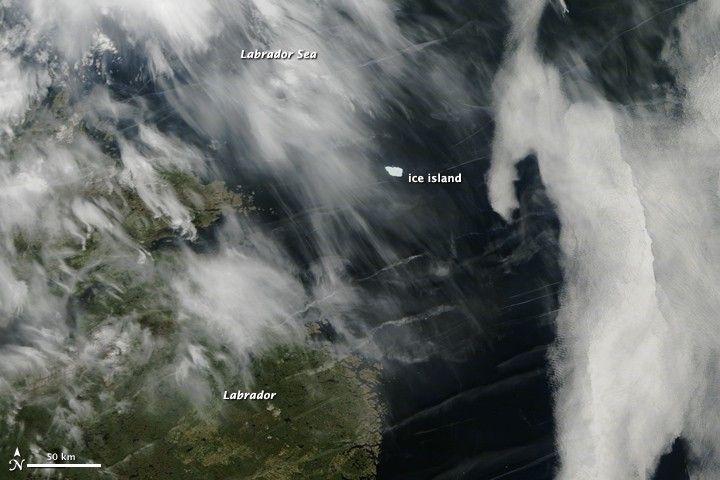
Nearly 11 months after calving off of the northwestern coast of Greenland, a massive ice island is now caught up in ocean currents off the coast of Labrador, Canada. The ice island was formed when a 251-square-kilometer (97-square-mile) chunk of ice broke off the Petermann Glacier on August 5, 2010. The Canadian Ice Service has since been tracking the ice island, dubbed PII-A, via satellite and radio beacon.
The Moderate Resolution Imaging Spectroradiometer (MODIS) on NASA’s Aqua satellite captured this natural-color image of the ice island on June 25, 2011. The northeast-facing coast of Labrador is mostly obscured by thin, wispy clouds, as it has been for much of the past week.
News agencies reported that the ice island stretched roughly 62 square kilometers in area and weighed between 3.5 and 4 billion tons. The island has been slowly breaking up and melting on its journey—nearly 30 degrees of latitude, or more than 3,000 kilometers—but it could eventually pose a hazard to offshore oil platforms and shipping lanes off Newfoundland. Canadian fishermen captured this close-up video of the ice island.
Environment Canada dropped a beacon on PII-A on September 17, 2010. You can track the island by clicking here. Satellite images of the area around Newfoundland are available twice daily from the MODIS Rapid Response System.
References & Resources
- Canadian Ice Service (n.d.) Petermann Ice Island Updates. Accessed July 1, 2011.
- CBC News (2011, June 23) Massive ice island heading for southern Labrador. Accessed July 1, 2011.
- Regina Global News Online (2011, June 28) Nfld. ice island triggers Arctic ice worries. Accessed July 1, 2011.
NASA image courtesy Jeff Schmaltz, MODIS Rapid Response Team at NASA GSFC. Caption by Michael Carlowicz.


