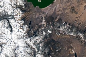


This perspective view shows the western side of the volcanically active KamchatkaPeninsula, Russia. The data are from the first C-band mapping swath of theShuttle Radar Topography Mission (SRTM). In the foreground is the broad, flatfloodplain of the Amanina River, shown in blue. In background of the image is theSredinnyy Khrebet, the volcanic mountain range that makes up the "spine" of thepeninsula. The cluster of hills in the upper right is a field of small dormantvolcanoes. High resolution SRTM topographic data will be used by geologists tostudy how volcanoes form and understand the hazards posed by future eruptions.
This shaded relief perspective view was generated using topographic data from theShuttle Radar Topography Mission. A computer-generated artificial light sourceilluminates the elevation data to produce a pattern of light and shadows. Slopesfacing the light appear bright, while those facing away are shaded. On flattersurfaces, the pattern of light and shadows can reveal subtle features in theterrain. Colors show the elevation as measured by SRTM. Colors range from blue atthe lowest elevations to white at the highest elevations. This image containsabout 2300 meters (7500 feet) of total relief. To emphasize subtle differences intopography, the relief is exaggerated by a factor of 5.
Size: 80 km (50 miles) x 100 km (62 miles) Location: 57.5 deg. North lat., 158.8deg. East lon. Orientation: View toward the East Data Resolution: 30 meters (99feet) Date Acquired: February 12, 2000
For more information, see the SRTM Site
References & Resources
Image by NASA/JPL/NIMA
None