


The Amazon Rainforest is a tangle of multiple layers of vegetation stretching from the ground to the top of the forest canopy. Layer upon layer of leaves intercept sunlight, inhale carbon dioxide, and exhale oxygen and water vapor. In 2007, a team of scientists discovered that behind its evergreen exterior, the Amazon was hiding a seasonal secret: large, previously unknown swings in leaf surface area between the wet season and the dry season. The seasonal secret was uncovered using leaf area measurements made by the Moderate Resolution Imaging Spectroradiometer (MODIS) on NASA’s Terra satellite.
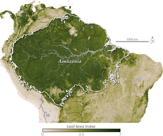
The map above is a multi-year average of the leaf area index of the Amazon based on Terra MODIS data. Leaf area index is the ratio of the leaf surface area to ground surface area. Values above 1 indicate multiple overlapping leaves, like the multi-tiered branches of a tree’s crown or multiple layers of vegetation. Not surprisingly, leaf area index is high throughout the Amazon (dark green), tapering off (light green) in the savannas and grasslands to the south, where vegetation is more sparse. The Andes to the west are almost completely barren (beige).
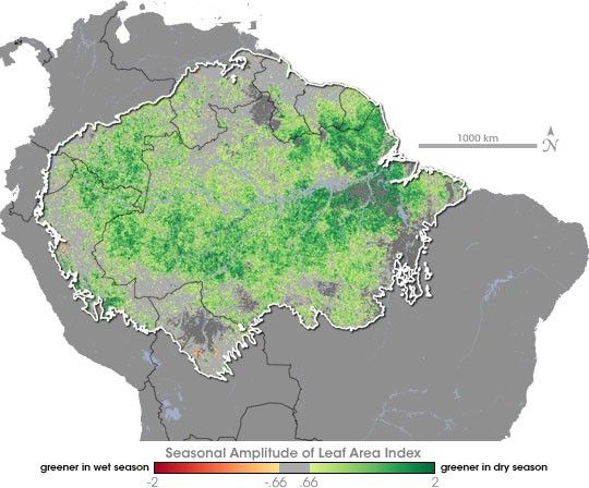
More surprising than the seasonal leaf area changes themselves were when in the year they occurred. Much of the Amazon experiences a pronounced dry season, with some areas in the south and east going half a year or more with little or no rain. But rain, it seems, is not the key limiting factor of plant growth in much of the Amazon, at least in normal years. The forest apparently puts on a flush of new growth in anticipation of the dry season, when the rainy season clouds disappear, and sunlight is abundant. MODIS observed that leaf area is higher in the Amazon dry season than the wet season. To read more about the discovery of these seasonal changes in the Amazon forest and the influence scientists think the forest might have on the rainfall itself, please read the Earth Observatory’s feature story The Amazon’s Seasonal Secret.
References & Resources
NASA map by Robert Simmon, based on MODIS data from the Boston University Climate and Vegetation Research Group.


