


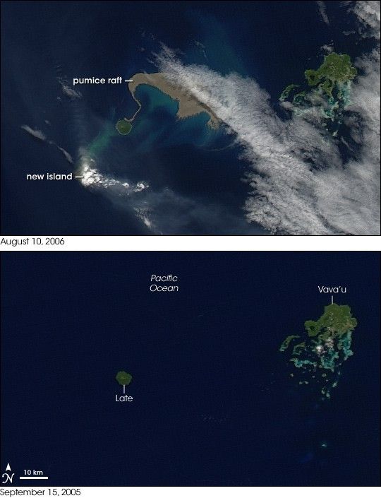
- August 10, 2006 (Aqua MODIS; 1.8 MB)
- September 15, 2005 (Aqua MODIS; 1.5 MB)
- Additional images in time series from NASA’s OceanColor Website
August 2006 brought two new things to the Tonga Islands in the South Pacific. One was a raft of lightweight, frothy volcanic rock—pumice—floating on the ocean surface. The other was a new island emerging out of the water. The Moderate Resolution Imaging Spectroradiometer (MODIS) flying onboard NASA’s Aqua satellite captured the aftermath of the eruption on August 10, 2006 (top), at 1:30 UTC (2:30 p.m. local time). For comparison, the bottom image shows the same area on September 15, 2005.
In the top image, the emerging volcanic island is partially hidden by its own plume. Volcanic plumes often appear drab gray or beige compared to clouds, and plumes from the emerging island move away from it in different directions, one to the southeast, and some to the north. The bright white spot directly over the island may be cloud cover, or it could be steam resulting from volcanic emissions.
The raft of pumice appears to the northeast of the emerging island, and it actually connects, via a thin thread, to neighboring Late Island. The blue-green color of the water around the raft and the new island is probably fine sediment that is making the deep blue water more reflective. The pumice raft gained international attention when a news report from Tonga Online described the experience of a yacht crew that inadvertently encountered the pumice raft. The “sea of stone” clogged the yacht’s engine-cooling system, forcing the vessel to turn back.
Pumice rafts are not an everyday occurrence, but they have been observed before. In 1986, a pumice raft of unknown origin caused engine trouble for a Dutch vessel in the South China Sea. Biologists have also proposed pumice rafts as a way to explain how plants and animals spread from island to island in marine environments.
A 250-meter-resolution KMZ file of the new volcanic island in the Tonga Islands is available for use with Google Earth.
References & Resources
NASA images by Jesse Allen, NASA Earth Observatory, based on data from the MODIS Rapid Response System, Goddard Space Flight Center.
None


