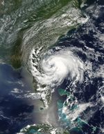
Beryl first formed as a subtropical storm over the Atlantic Ocean on May 25, 2012. The U.S. National Hurricane Center (NHC) tracked the storm’s progress, and at 2:00 p.m. Eastern Daylight Time (EDT) on May 27, the NHC announced that the storm was located roughly 110 miles (175 kilometers) east of Jacksonville, Florida. Having strengthened into a tropical storm, Beryl had maximum sustained winds of 65 miles (100 kilometers) per hour.
The Moderate Resolution Imaging Spectroradiometer (MODIS) on NASA’s Aqua satellite captured this natural-color image of Beryl on May 27, around 2:30 p.m. EDT. Beryl was making landfall along Florida’s east coast. The NHC warned that the hazards affecting land included high winds and flooding resulting from a combination of the storm surge and the tide.
References & Resources
- National Hurricane Center. (2012, May 29) Tropical Storm Beryl Advisory Archive. Accessed May 29, 2012.
NASA image courtesy Jeff Schmaltz, LANCE MODIS Rapid Response Team, Goddard Space Flight Center. Caption by Michon Scott.