“Ernesto could become a hurricane tonight,” the U.S. National Hurricane Center (NHC) warned at 2:00 p.m. Eastern Daylight Time on August 6, 2012. The storm was headed in the direction of the Yucatán Peninsula, traveling at roughly 12 miles (19 kilometers) per hour.
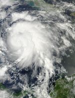
The Moderate Resolution Imaging Spectroradiometer (MODIS) on NASA’s Terra satellite captured this natural-color image of Tropical Storm Ernesto around 11:35 a.m. EDT on August 6. Although the storm lacked a distinct eye, it still sported the semicolon shape characteristic of strong storms.
In a bulletin issued shortly after MODIS acquired this image, the NHC reported that Ernesto had maximum sustained winds of 65 miles (100 kilometers) per hour. The storm was located about 160 miles (260 kilometers) east-northeast of Cabo Gracias a Dios on the Nicaragua-Honduras border. A hurricane warning was in effect for part of the east coast of the Yucatán Peninsula, from Chetumal to Punta Allen. A hurricane watch was in effect for entire coast of Belize.
References & Resources
- National Hurricane Center. (2012, August 6) Tropical Storm Ernesto Advisory Archive. Accessed August 6, 2012.
NASA image courtesy Jeff Schmaltz, LANCE MODIS Rapid Response Team, Goddard Space Flight Center. Caption by Michon Scott.