


![Request for Information – Potential [Placeholder for Prize]](https://assets.science.nasa.gov/dynamicimage/assets/science/psd/solar/2023/09/s/solarsystem_0.jpg?w=1024)


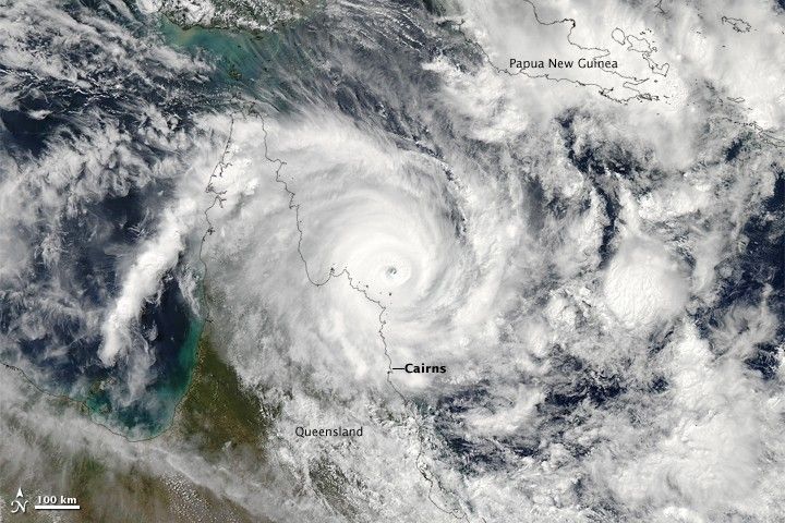
NASA’s Aqua satellite captured this image of Tropical Cyclone Ita as it bore down on Australia’s Cook Peninsula in April 2014. About 30,000 residents of Cairns were asked to evacuate in advance of the storm, and storm surge and wind damage alerts were issued across northern Queensland.
The image was acquired by Aqua’s Moderate Resolution Imaging Spectroradiometer (MODIS) at 2 p.m. local time (0400 Universal Time) on April 11. About two hours later, according to Unisys Weather, the storm had maximum sustained winds of 232 kilometers (144 miles) per hour, a category 4 cyclone.
Ita later made landfall near Cape Flattery, north of Cooktown, around 9 p.m. on April 11. By 4 a.m. local time on April 12, meteorologists reported that the storm was moving south-southwest through the state of Queensland with sustained winds at roughly 140 kilometers (90 miles) per hour. Ita was predicted to remain at least a category 1 cyclone though late afternoon on April 12.
In the days before arriving in Queensland, the tropical weather system that became Ita dumped intense rain on the Solomon Islands, leading to flash floods and landslides that killed at least 20 people and affected at least 50,000. It also brought flooding and power outages to eastern Papua New Guinea and nearby islands.
MODIS captured earlier images of Ita on April 6, April 8, and April 10.
References & Resources
- Australian Broadcasting Corporation (2014, April 12) Cyclone Ita: live coverage as storm hits far north Queensland. Accessed April 11, 2014.
- Australian Bureau of Meteorology (2014) Current Tropical Cyclones. Accessed April 11, 2014.
- The Guardian (2014, April 11) Cyclone Ita expected to make landfall on Friday night near Cooktown. Accessed April 11, 2014.
- ReliefWeb (2014, April) Solomon Islands: Flash Floods Situation Report. Accessed April 11, 2014.
- U.S. Naval Observatory (2014) Joint Typhoon Warning Center. Accessed April 11, 2014.
NASA image courtesy Jeff Schmaltz, LANCE/EOSDIS MODIS Rapid Response Team at NASA GSFC. Caption by Mike Carlowicz.


