

















September 5, 2016
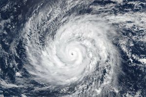
At 11:45 a.m. Mountain Daylight Time on September 5, 2016, the Moderate Resolution Imaging Spectroradiometer (MODIS) on NASA’s Terra satellite captured this image of Tropical Storm Newton, located about 440 kilometers (235 miles) south-southeast of Cabo San Lucas, Mexico. Maximum sustained winds were about 105 kilometers (65 miles) per hour.
The storm strengthened and on September 6, Newton was a category-1 hurricane with maximum sustained winds of 130 kilometers (80 miles) per hour. According to news reports, tourism resorts were affected by the strong winds and rain when the hurricane made landfall on Mexico’s Baja California peninsula.
References & Resources
- National Hurricane Center (2016, September 5) Tropical Storm Newton Intermediate Advisory Number 4A. Accessed September 6, 2016.
- Reuters (2016, September 6) Hurricane Newton storms up Mexico's Baja California peninsula. Accessed September 6, 2016.
- UniSys Weather (2016, September 4-6) Hurricane-1 Newton. Accessed September 6, 2016.
NASA image by Jeff Schmaltz, LANCE/EOSDIS Rapid Response . Caption by Kathryn Hansen.